Beiwu geodata
Beiwu (Beijing) is a seat of a fourth-order administrative division; located in China in Asia/Shanghai (GMT+8) time zone. In our database, there are 1268 cities with bigger population. Compared to other cities in China, 86.6% of cities are located further ↓South; 65.1% of cities are located further ←West and 75.3% of cities have higher elevation than Beiwu. Note1


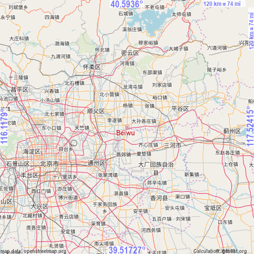
Beiwu GPS coordinates[2]
40° 3' 27.216" North, 116° 49' 15.672" East
| Map corner | latitude | longitude |
|---|---|---|
| Upper-left | 40.5936°, | 116.1179° |
| Center: | 40.05756°, | 116.82102° |
| Lower-right: | 39.51727°, | 117.52415° |
| Map W x H: | 119.7×119.7 km | = 74.4×74.4mi |
| max Lat: | 53.31946° ⇑13.4% North |
| Beiwu: | 40.05756° |
| min Lat: | ⇓86.6% South 18.22056° |
| min Long | Beiwu | max Long |
| 75.07348° | 116.82102° | 134.28917° |
| W 65.1%⇐ | ⇒34.9% E |
Elevation
Elevation of Beiwu is 36 m = 118 ft, and this is 448.8 m = 1472 ft below average elevation for this country.
| Max E: |
5622 m = 18445 ft | 75.3% |
| Avg. | 484.8 m = 1591 ft | |
| Beiwu | 36 m = 118 ft | |
Min E: |
-3 m = -10 ft | 24.7% |
See also: China elevation on elevation.city.
Geographical zone
Beiwu is located in North temperate zone (between Tropic of Cancer and the Arctic Circle). Distance of this Northern Tropic circle is 1848.1 km =1148.4 mi to South.| Distance of | km | miles | from Beiwu |
|---|---|---|---|
| North Pole | 5553.1 | 3450.5 | to North |
| Arctic Circle | 2947.2 | 1831.3 | to North |
| Tropic Cancer | 1848.1 | 1148.4 | to South |
| Equator | 4454 | 2767.6 | to South |


Nearby cities:
15 places around Beiwu: (largest is in red/bold)
• Beixiaoying
17.8 km =11.1 mi,  331°
331°
• Liqiao
16 km =9.9 mi,  271°
271°
• Lisui
6.9 km =4.3 mi,  299°
299°
• Longwantun
18.6 km =11.6 mi,  9°
9°
• Machangying
18.8 km =11.7 mi,  61°
61°
• Mafang
16.3 km =10.1 mi,  81°
81°
• Mulin
20.9 km =13 mi,  350°
350°
• Nancai
13.8 km =8.6 mi,  309°
309°
• Nanfaxin
19.9 km =12.4 mi,  290°
290°
• Shengli
16.6 km =10.3 mi, 293°
• Shunyi
16.4 km =10.2 mi, 295°
• Songzhuang
14.7 km =9.1 mi,  213°
213°
• Ximapo
19.1 km =11.9 mi, 309°
• Yangzhen
10.5 km =6.5 mi,  358°
358°
• Zhangzhen
14.5 km =9 mi,  47°
47°
Sources, notices
• [Note1] Compared only with cities in China existing in our database
• [Src1] Map data: © OpenStreetMap contributors (CC-BY-SA)
• [Src2] Other city data from geonames.org with taken over terms of usage.
• [Src3] Geographical zone / Annual Mean Temperature by Robert A. Rohde @ Wikipedia
