Longwantun geodata
Longwantun (Beijing) is a seat of a fourth-order administrative division; located in China in Asia/Shanghai (GMT+8) time zone. In our database, there are 1268 cities with bigger population. Compared to other cities in China, 87.3% of cities are located further ↓South; 65.3% of cities are located further ←West and 70.5% of cities have higher elevation than Longwantun. Note1


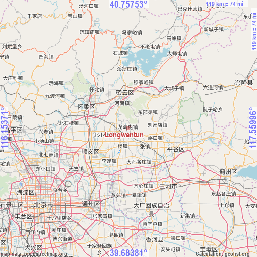
Longwantun GPS coordinates[2]
40° 13' 22.08" North, 116° 51' 24.588" East
| Map corner | latitude | longitude |
|---|---|---|
| Upper-left | 40.75753°, | 116.15371° |
| Center: | 40.2228°, | 116.85683° |
| Lower-right: | 39.68381°, | 117.55996° |
| Map W x H: | 119.4×119.4 km | = 74.2×74.2mi |
| max Lat: | 53.31946° ⇑12.7% North |
| Longwantun: | 40.2228° |
| min Lat: | ⇓87.3% South 18.22056° |
| min Long | Longwantun | max Long |
| 75.07348° | 116.85683° | 134.28917° |
| W 65.3%⇐ | ⇒34.7% E |
Elevation
Elevation of Longwantun is 50 m = 164 ft, and this is 434.8 m = 1427 ft below average elevation for this country.
| Max E: |
5622 m = 18445 ft | 70.5% |
| Avg. | 484.8 m = 1591 ft | |
| Longwantun | 50 m = 164 ft | |
Min E: |
-3 m = -10 ft | 29.5% |
See also: China elevation on elevation.city.
Geographical zone
Longwantun is located in North temperate zone (between Tropic of Cancer and the Arctic Circle). Distance of this Northern Tropic circle is 1866.4 km =1159.7 mi to South.| Distance of | km | miles | from Longwantun |
|---|---|---|---|
| North Pole | 5534.7 | 3439.1 | to North |
| Arctic Circle | 2928.8 | 1819.9 | to North |
| Tropic Cancer | 1866.4 | 1159.7 | to South |
| Equator | 4472.4 | 2779 | to South |


Nearby cities:
15 places around Longwantun: (largest is in red/bold)
• Beixiaoying
11.9 km =7.4 mi,  256°
256°
• Daxingzhuang
18.1 km =11.2 mi,  117°
117°
• Dongshaoqu
11.3 km =7 mi,  49°
49°
• Gulou
16.5 km =10.3 mi,  353°
353°
• Henanzhai
12.8 km =8 mi, 350°
• Lisui
17.5 km =10.9 mi,  211°
211°
• Machangying
16.4 km =10.2 mi,  125°
125°
• Mulin
6.7 km =4.2 mi,  289°
289°
• Nancai
16.7 km =10.4 mi,  234°
234°
• Niulanshan
17.3 km =10.7 mi,  267°
267°
• Shilibu
16 km =9.9 mi,  341°
341°
• Yangsong
17.2 km =10.7 mi,  297°
297°
• Yangzhen
8.6 km =5.3 mi,  203°
203°
• Yukou
13 km =8.1 mi,  107°
107°
• Zhangzhen
11.4 km =7.1 mi,  138°
138°
Sources, notices
• [Note1] Compared only with cities in China existing in our database
• [Src1] Map data: © OpenStreetMap contributors (CC-BY-SA)
• [Src2] Other city data from geonames.org with taken over terms of usage.
• [Src3] Geographical zone / Annual Mean Temperature by Robert A. Rohde @ Wikipedia
