Xiaozhuangzi geodata
Xiaozhuangzi (Liaoning) is a seat of a fourth-order administrative division; located in China in Asia/Shanghai (GMT+8) time zone. In our database, there are 1268 cities with bigger population. Compared to other cities in China, 87.4% of cities are located further ↓South; 84.6% of cities are located further ←West and 97.2% of cities have higher elevation than Xiaozhuangzi. Note1


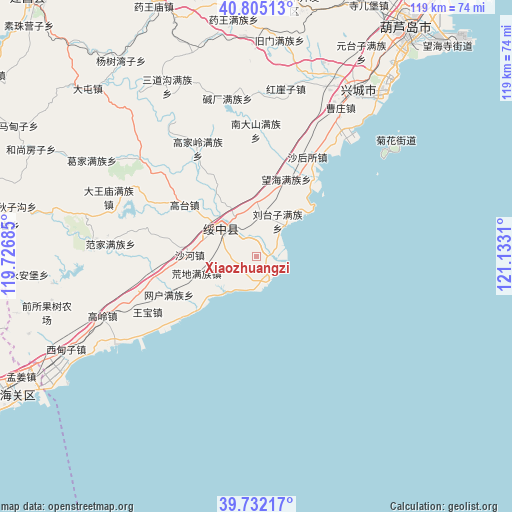
Xiaozhuangzi GPS coordinates[2]
40° 16' 14.808" North, 120° 25' 47.892" East
| Map corner | latitude | longitude |
|---|---|---|
| Upper-left | 40.80513°, | 119.72685° |
| Center: | 40.27078°, | 120.42997° |
| Lower-right: | 39.73217°, | 121.1331° |
| Map W x H: | 119.3×119.3 km | = 74.1×74.1mi |
| max Lat: | 53.31946° ⇑12.6% North |
| Xiaozhuangzi: | 40.27078° |
| min Lat: | ⇓87.4% South 18.22056° |
| min Long | Xiaozhuangzi | max Long |
| 75.07348° | 120.42997° | 134.28917° |
| W 84.6%⇐ | ⇒15.4% E |
Elevation
Elevation of Xiaozhuangzi is 5 m = 16 ft, and this is 479.8 m = 1574 ft below average elevation for this country.
| Max E: |
5622 m = 18445 ft | 97.2% |
| Avg. | 484.8 m = 1591 ft | |
| Xiaozhuangzi | 5 m = 16 ft | |
Min E: |
-3 m = -10 ft | 2.8% |
See also: China elevation on elevation.city.
Geographical zone
Xiaozhuangzi is located in North temperate zone (between Tropic of Cancer and the Arctic Circle). Distance of this Northern Tropic circle is 1871.8 km =1163.1 mi to South.| Distance of | km | miles | from Xiaozhuangzi |
|---|---|---|---|
| North Pole | 5529.4 | 3435.8 | to North |
| Arctic Circle | 2923.5 | 1816.6 | to North |
| Tropic Cancer | 1871.8 | 1163.1 | to South |
| Equator | 4477.7 | 2782.3 | to South |


Nearby cities:
15 places around Xiaozhuangzi: (largest is in red/bold)
• Chengjiao
10.4 km =6.5 mi,  313°
313°
• Fanjia
34 km =21.1 mi,  274°
274°
• Gaodianzi
27.7 km =17.2 mi,  296°
296°
• Gaoling
38.4 km =23.9 mi,  248°
248°
• Gaotai
20.6 km =12.8 mi, 305°
• Guta
29.5 km =18.3 mi, 252°
• Huangdi
14.5 km =9 mi, 253°
• Kuanbang
37.1 km =23.1 mi,  315°
315°
• Piaojia
22.2 km =13.8 mi, 246°
• Shahe
15.6 km =9.7 mi, 271°
• Suizhong
10.2 km =6.3 mi, 309°
• Tashantun
3.4 km =2.1 mi,  238°
238°
• Wangbao
28.5 km =17.7 mi, 242°
• Xipingpo
29.5 km =18.3 mi, 312°
• 城郊
10.4 km =6.5 mi, 313°
Sources, notices
• [Note1] Compared only with cities in China existing in our database
• [Src1] Map data: © OpenStreetMap contributors (CC-BY-SA)
• [Src2] Other city data from geonames.org with taken over terms of usage.
• [Src3] Geographical zone / Annual Mean Temperature by Robert A. Rohde @ Wikipedia
