Gaoling geodata
Gaoling (Liaoning) is a seat of a fourth-order administrative division; located in China in Asia/Shanghai (GMT+8) time zone. In our database, there are 1268 cities with bigger population. Compared to other cities in China, 86.9% of cities are located further ↓South; 82% of cities are located further ←West and 74.4% of cities have higher elevation than Gaoling. Note1


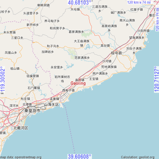
Gaoling GPS coordinates[2]
40° 8' 44.448" North, 120° 0' 29.304" East
| Map corner | latitude | longitude |
|---|---|---|
| Upper-left | 40.68103°, | 119.30502° |
| Center: | 40.14568°, | 120.00814° |
| Lower-right: | 39.60608°, | 120.71127° |
| Map W x H: | 119.5×119.5 km | = 74.3×74.3mi |
| max Lat: | 53.31946° ⇑13.1% North |
| Gaoling: | 40.14568° |
| min Lat: | ⇓86.9% South 18.22056° |
| min Long | Gaoling | max Long |
| 75.07348° | 120.00814° | 134.28917° |
| W 82%⇐ | ⇒18% E |
Elevation
Elevation of Gaoling is 38 m = 125 ft, and this is 446.8 m = 1466 ft below average elevation for this country.
| Max E: |
5622 m = 18445 ft | 74.4% |
| Avg. | 484.8 m = 1591 ft | |
| Gaoling | 38 m = 125 ft | |
Min E: |
-3 m = -10 ft | 25.6% |
See also: China elevation on elevation.city.
Geographical zone
Gaoling is located in North temperate zone (between Tropic of Cancer and the Arctic Circle). Distance of this Northern Tropic circle is 1857.9 km =1154.4 mi to South.| Distance of | km | miles | from Gaoling |
|---|---|---|---|
| North Pole | 5543.3 | 3444.4 | to North |
| Arctic Circle | 2937.4 | 1825.2 | to North |
| Tropic Cancer | 1857.9 | 1154.4 | to South |
| Equator | 4463.8 | 2773.7 | to South |


Nearby cities:
15 places around Gaoling: (largest is in red/bold)
• Dadianzi
19.6 km =12.2 mi,  299°
299°
• Fanjia
16.9 km =10.5 mi,  6°
6°
• Gaodianzi
28.7 km =17.8 mi,  22°
22°
• Guta
9.2 km =5.7 mi,  56°
56°
• Huangdi
24.1 km =15 mi,  65°
65°
• Jiabeiyan
31.1 km =19.3 mi,  311°
311°
• Lijiabao
17.7 km =11 mi,  256°
256°
• Mingshui
26.1 km =16.2 mi,  336°
336°
• Piaojia
16.3 km =10.1 mi, 71°
• Qiansuo
7.6 km =4.7 mi,  222°
222°
• Shahe
24.7 km =15.3 mi,  54°
54°
• Shanhaiguan
27.2 km =16.9 mi,  234°
234°
• Wangbao
10.5 km =6.5 mi,  84°
84°
• Wangjiazhuang
16.5 km =10.3 mi, 232°
• Xidianzi
8.9 km =5.5 mi, 223°
Sources, notices
• [Note1] Compared only with cities in China existing in our database
• [Src1] Map data: © OpenStreetMap contributors (CC-BY-SA)
• [Src2] Other city data from geonames.org with taken over terms of usage.
• [Src3] Geographical zone / Annual Mean Temperature by Robert A. Rohde @ Wikipedia
