Hepingjie geodata
Hepingjie (Jilin) is a seat of a fourth-order administrative division; located in China in Asia/Shanghai (GMT+8) time zone. With population of 65,298 people, there are 666 cities with bigger population in this country. Compared to other cities in China, 91.1% of cities are located further ↓South; 96.5% of cities are located further ←West and 80.8% of cities have lower elevation than Hepingjie. Note1


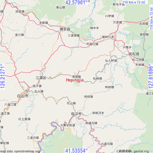
Hepingjie GPS coordinates[2]
42° 3' 34.992" North, 126° 54' 56.988" East
| Map corner | latitude | longitude |
|---|---|---|
| Upper-left | 42.57961°, | 126.21271° |
| Center: | 42.05972°, | 126.91583° |
| Lower-right: | 41.53554°, | 127.61896° |
| Map W x H: | 116.1×116.1 km | = 72.1×72.1mi |
| max Lat: | 53.31946° ⇑8.9% North |
| Hepingjie: | 42.05972° |
| min Lat: | ⇓91.1% South 18.22056° |
| min Long | Hepingjie | max Long |
| 75.07348° | 126.91583° | 134.28917° |
| W 96.5%⇐ | ⇒3.5% E |
Elevation
Elevation of Hepingjie is 730 m = 2395 ft, and this is 245.2 m = 804 ft above average elevation for this country.
| Max E: |
5622 m = 18445 ft | 19.2% |
| Hepingjie | 730 m 2395 ft | |
| Avg. | 484.8 m = 1591 ft | |
Min E: |
-3 m = -10 ft | 80.8% |
See also: Hepingjie elevation on elevation.city.
Geographical zone
Hepingjie is located in North temperate zone (between Tropic of Cancer and the Arctic Circle). Distance of this Northern Tropic circle is 2070.7 km =1286.7 mi to South.| Distance of | km | miles | from Hepingjie |
|---|---|---|---|
| North Pole | 5330.5 | 3312.2 | to North |
| Arctic Circle | 2724.6 | 1693 | to North |
| Tropic Cancer | 2070.7 | 1286.7 | to South |
| Equator | 4676.6 | 2905.9 | to South |


Nearby cities:
15 places around Hepingjie: (largest is in red/bold)
• Dashiren
33.6 km =20.9 mi,  245°
245°
• Huashan
19.9 km =12.4 mi,  191°
191°
• Huashu
26.1 km =16.2 mi,  107°
107°
• Huayuankou
28 km =17.4 mi,  25°
25°
• Jinjiadian
31.6 km =19.6 mi,  356°
356°
• Linjiang
28.1 km =17.5 mi,  181°
181°
• Mayihe
31.7 km =19.7 mi,  148°
148°
• Naozhi
17.3 km =10.7 mi, 148°
• Sanchazi
26.2 km =16.3 mi,  275°
275°
• Shiren
30.8 km =19.1 mi, 249°
• Songshu
15.9 km =9.9 mi,  96°
96°
• Sunjia Buzi
27.7 km =17.2 mi,  260°
260°
• Xianrenqiao
28.9 km =18 mi,  64°
64°
• Yanping
23.2 km =14.4 mi, 359°
• Zhazi
30.2 km =18.8 mi, 258°
Sources, notices
• [Note1] Compared only with cities in China existing in our database
• [Src1] Map data: © OpenStreetMap contributors (CC-BY-SA)
• [Src2] Other city data from geonames.org with taken over terms of usage.
• [Src3] Geographical zone / Annual Mean Temperature by Robert A. Rohde @ Wikipedia
