Naozhi geodata
Naozhi (Jilin) is a seat of a fourth-order administrative division; located in China in Asia/Shanghai (GMT+8) time zone. In our database, there are 1268 cities with bigger population. Compared to other cities in China, 90.9% of cities are located further ↓South; 96.7% of cities are located further ←West and 74.4% of cities have lower elevation than Naozhi. Note1


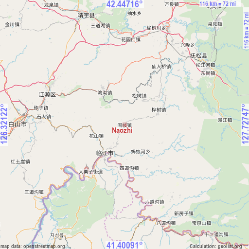
Naozhi GPS coordinates[2]
41° 55' 34.248" North, 127° 1' 27.624" East
| Map corner | latitude | longitude |
|---|---|---|
| Upper-left | 42.44716°, | 126.32122° |
| Center: | 41.92618°, | 127.02434° |
| Lower-right: | 41.40091°, | 127.72747° |
| Map W x H: | 116.3×116.3 km | = 72.3×72.3mi |
| max Lat: | 53.31946° ⇑9.1% North |
| Naozhi: | 41.92618° |
| min Lat: | ⇓90.9% South 18.22056° |
| min Long | Naozhi | max Long |
| 75.07348° | 127.02434° | 134.28917° |
| W 96.7%⇐ | ⇒3.3% E |
Elevation
Elevation of Naozhi is 508 m = 1667 ft, and this is 23.2 m = 76 ft above average elevation for this country.
| Max E: |
5622 m = 18445 ft | 25.6% |
| Naozhi | 508 m 1667 ft | |
| Avg. | 484.8 m = 1591 ft | |
Min E: |
-3 m = -10 ft | 74.4% |
See also: China elevation on elevation.city.
Geographical zone
Naozhi is located in North temperate zone (between Tropic of Cancer and the Arctic Circle). Distance of this Northern Tropic circle is 2055.8 km =1277.4 mi to South.| Distance of | km | miles | from Naozhi |
|---|---|---|---|
| North Pole | 5345.3 | 3321.4 | to North |
| Arctic Circle | 2739.4 | 1702.2 | to North |
| Tropic Cancer | 2055.8 | 1277.4 | to South |
| Equator | 4661.8 | 2896.7 | to South |


Nearby cities:
15 places around Naozhi: (largest is in red/bold)
• Dalizi
26.9 km =16.7 mi,  216°
216°
• Dongbeicha
30.3 km =18.8 mi,  133°
133°
• Hepingjie
17.3 km =10.7 mi,  328°
328°
• Huashan
13.9 km =8.6 mi,  250°
250°
• Huashu
17.5 km =10.9 mi,  65°
65°
• Jiajiaying
20.5 km =12.7 mi,  138°
138°
• Linjiang
16.4 km =10.2 mi, 216°
• Mayihe
14.3 km =8.9 mi,  148°
148°
• Shiren
38.1 km =23.7 mi,  276°
276°
• Sidaogou
20.3 km =12.6 mi,  173°
173°
• Songshu
14.7 km =9.1 mi,  27°
27°
• Sunjia Buzi
37.7 km =23.4 mi,  285°
285°
• Weishahe
31.1 km =19.3 mi,  227°
227°
• Xianrenqiao
32.2 km =20 mi, 32°
• Xinxigang
31.4 km =19.5 mi,  60°
60°
Sources, notices
• [Note1] Compared only with cities in China existing in our database
• [Src1] Map data: © OpenStreetMap contributors (CC-BY-SA)
• [Src2] Other city data from geonames.org with taken over terms of usage.
• [Src3] Geographical zone / Annual Mean Temperature by Robert A. Rohde @ Wikipedia
