Tuanshanzi geodata
Tuanshanzi (Heilongjiang) is a seat of a fourth-order administrative division; located in China in Asia/Shanghai (GMT+8) time zone. In our database, there are 1268 cities with bigger population. Compared to other cities in China, 95.5% of cities are located further ↓South; 99.1% of cities are located further ←West and 57.5% of cities have higher elevation than Tuanshanzi. Note1


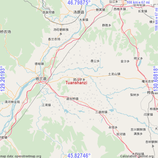
Tuanshanzi GPS coordinates[2]
46° 18' 54.936" North, 129° 54' 18.18" East
| Map corner | latitude | longitude |
|---|---|---|
| Upper-left | 46.79875°, | 129.20193° |
| Center: | 46.31526°, | 129.90505° |
| Lower-right: | 45.82746°, | 130.60818° |
| Map W x H: | 108×108 km | = 67.1×67.1mi |
| max Lat: | 53.31946° ⇑4.5% North |
| Tuanshanzi: | 46.31526° |
| min Lat: | ⇓95.5% South 18.22056° |
| min Long | Tuanshanzi | max Long |
| 75.07348° | 129.90505° | 134.28917° |
| W 99.1%⇐ | ⇒0.90000000000001% E |
Elevation
Elevation of Tuanshanzi is 114 m = 374 ft, and this is 370.8 m = 1217 ft below average elevation for this country.
| Max E: |
5622 m = 18445 ft | 57.5% |
| Avg. | 484.8 m = 1591 ft | |
| Tuanshanzi | 114 m = 374 ft | |
Min E: |
-3 m = -10 ft | 42.5% |
See also: China elevation on elevation.city.
Geographical zone
Tuanshanzi is located in North temperate zone (between Tropic of Cancer and the Arctic Circle). Distance of this North polar circle is 2251.4 km =1399 mi to North.| Distance of | km | miles | from Tuanshanzi |
|---|---|---|---|
| North Pole | 4857.3 | 3018.2 | to North |
| Arctic Circle | 2251.4 | 1399 | to North |
| Tropic Cancer | 2543.9 | 1580.7 | to South |
| Equator | 5149.8 | 3199.9 | to South |


Nearby cities:
15 places around Tuanshanzi: (largest is in red/bold)
• Dalai
40.9 km =25.4 mi,  4°
4°
• Daotaiqiao
13.9 km =8.6 mi,  200°
200°
• Hongkeli
29.3 km =18.2 mi,  350°
350°
• Jiangwan
28.7 km =17.8 mi,  232°
232°
• Lishu
39.4 km =24.5 mi,  105°
105°
• Qingfa
16.2 km =10.1 mi,  81°
81°
• Sandaogang
27.1 km =16.8 mi,  145°
145°
• Tangwang
34.9 km =21.7 mi,  339°
339°
• Tulongshan
24.1 km =15 mi, 81°
• Xianglan
39 km =24.2 mi, 342°
• Yilan
26.9 km =16.7 mi,  270°
270°
• Yinglan
27.9 km =17.3 mi,  275°
275°
• Yongheng
36.4 km =22.6 mi, 146°
• Yugong
16.7 km =10.4 mi,  40°
40°
• Zhulian
31.9 km =19.8 mi, 354°
Sources, notices
• [Note1] Compared only with cities in China existing in our database
• [Src1] Map data: © OpenStreetMap contributors (CC-BY-SA)
• [Src2] Other city data from geonames.org with taken over terms of usage.
• [Src3] Geographical zone / Annual Mean Temperature by Robert A. Rohde @ Wikipedia
