Yilan geodata
Yilan (Heilongjiang) is a seat of a third-order administrative division; located in China in Asia/Shanghai (GMT+8) time zone. With population of 71,180 people, there are 602 cities with bigger population in this country. Compared to other cities in China, 95.5% of cities are located further ↓South; 98.8% of cities are located further ←West and 60.1% of cities have higher elevation than Yilan. Note1


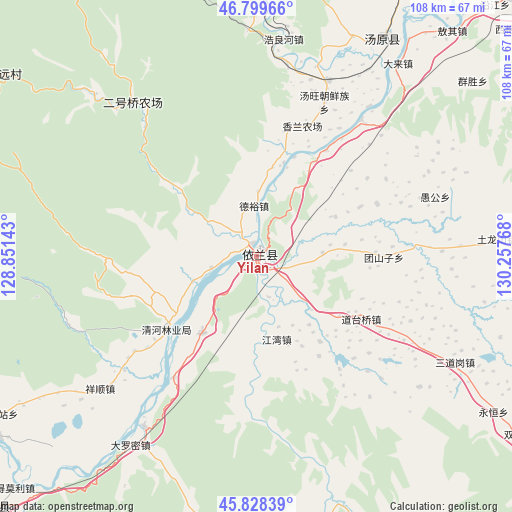
Yilan GPS coordinates[2]
46° 18' 58.248" North, 129° 33' 16.38" East
| Map corner | latitude | longitude |
|---|---|---|
| Upper-left | 46.79966°, | 128.85143° |
| Center: | 46.31618°, | 129.55455° |
| Lower-right: | 45.82839°, | 130.25768° |
| Map W x H: | 108×108 km | = 67.1×67.1mi |
| max Lat: | 53.31946° ⇑4.5% North |
| Yilan: | 46.31618° |
| min Lat: | ⇓95.5% South 18.22056° |
| min Long | Yilan | max Long |
| 75.07348° | 129.55455° | 134.28917° |
| W 98.8%⇐ | ⇒1.2% E |
Elevation
Elevation of Yilan is 98 m = 322 ft, and this is 386.8 m = 1269 ft below average elevation for this country.
| Max E: |
5622 m = 18445 ft | 60.1% |
| Avg. | 484.8 m = 1591 ft | |
| Yilan | 98 m = 322 ft | |
Min E: |
-3 m = -10 ft | 39.9% |
See also: Yilan elevation on elevation.city.
Geographical zone
Yilan is located in North temperate zone (between Tropic of Cancer and the Arctic Circle). Distance of this North polar circle is 2251.3 km =1398.9 mi to North.| Distance of | km | miles | from Yilan |
|---|---|---|---|
| North Pole | 4857.2 | 3018.1 | to North |
| Arctic Circle | 2251.3 | 1398.9 | to North |
| Tropic Cancer | 2544 | 1580.8 | to South |
| Equator | 5149.9 | 3200 | to South |


Nearby cities:
15 places around Yilan: (largest is in red/bold)
• Dalianhe
20 km =12.4 mi,  215°
215°
• Daotaiqiao
25.8 km =16 mi,  120°
120°
• Haolianghe
46 km =28.6 mi,  7°
7°
• Hongkeli
36.3 km =22.6 mi,  37°
37°
• Jiangwan
18 km =11.2 mi,  166°
166°
• Qingfa
43 km =26.7 mi,  87°
87°
• Qinghe
24 km =14.9 mi,  231°
231°
• Sandaogang
47.8 km =29.7 mi, 117°
• Tangwang
35.5 km =22.1 mi,  23°
23°
• Tuanshanzi
26.9 km =16.7 mi, 90°
• Xianglan
40 km =24.9 mi, 22°
• Xiangshun
43.2 km =26.8 mi, 229°
• Yinglan
2.8 km =1.7 mi,  343°
343°
• Yugong
39.8 km =24.7 mi,  71°
71°
• Zhulian
39.6 km =24.6 mi, 36°
Sources, notices
• [Note1] Compared only with cities in China existing in our database
• [Src1] Map data: © OpenStreetMap contributors (CC-BY-SA)
• [Src2] Other city data from geonames.org with taken over terms of usage.
• [Src3] Geographical zone / Annual Mean Temperature by Robert A. Rohde @ Wikipedia
