Tonghua geodata
Tonghua (Jilin) is a seat of a second-order administrative division; located in China in Asia/Shanghai (GMT+8) time zone. With population of 510,000 people, there are 126 cities with bigger population in this country. Compared to other cities in China, 90.5% of cities are located further ↓South; 95.4% of cities are located further ←West and 67.9% of cities have lower elevation than Tonghua. Note1


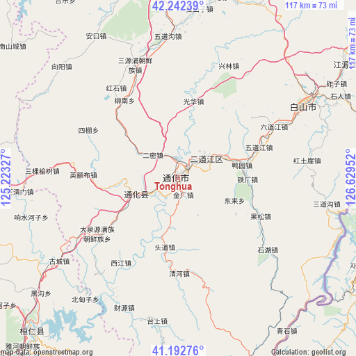
Tonghua GPS coordinates[2]
41° 43' 10.992" North, 125° 55' 35.004" East
| Map corner | latitude | longitude |
|---|---|---|
| Upper-left | 42.24239°, | 125.22327° |
| Center: | 41.71972°, | 125.92639° |
| Lower-right: | 41.19276°, | 126.62952° |
| Map W x H: | 116.7×116.7 km | = 72.5×72.5mi |
| max Lat: | 53.31946° ⇑9.5% North |
| Tonghua: | 41.71972° |
| min Lat: | ⇓90.5% South 18.22056° |
| min Long | Tonghua | max Long |
| 75.07348° | 125.92639° | 134.28917° |
| W 95.4%⇐ | ⇒4.6% E |
Elevation
Elevation of Tonghua is 375 m = 1230 ft, and this is 109.8 m = 360 ft below average elevation for this country.
| Max E: |
5622 m = 18445 ft | 32.1% |
| Avg. | 484.8 m = 1591 ft | |
| Tonghua | 375 m = 1230 ft | |
Min E: |
-3 m = -10 ft | 67.9% |
See also: Tonghua elevation on elevation.city.
Geographical zone
Tonghua is located in North temperate zone (between Tropic of Cancer and the Arctic Circle). Distance of this Northern Tropic circle is 2032.9 km =1263.2 mi to South.| Distance of | km | miles | from Tonghua |
|---|---|---|---|
| North Pole | 5368.3 | 3335.7 | to North |
| Arctic Circle | 2762.4 | 1716.5 | to North |
| Tropic Cancer | 2032.9 | 1263.2 | to South |
| Equator | 4638.8 | 2882.4 | to South |


Nearby cities:
15 places around Tonghua: (largest is in red/bold)
• Daduling
22.6 km =14 mi,  239°
239°
• Da’an
21.1 km =13.1 mi,  52°
52°
• Donglai
19.6 km =12.2 mi,  112°
112°
• Erdaojiang
10.8 km =6.7 mi, 54°
• Ermi
11 km =6.8 mi,  313°
313°
• Gangou
23.7 km =14.7 mi, 312°
• Guanghua
25.6 km =15.9 mi,  11°
11°
• Hulutao
8.3 km =5.2 mi, 7°
• Jindou
19.6 km =12.2 mi,  265°
265°
• Kuaidamao
16.9 km =10.5 mi, 244°
• Liudaogou
29.8 km =18.5 mi, 114°
• Qinghe
31.2 km =19.4 mi,  179°
179°
• Tongshanjie
14.8 km =9.2 mi,  334°
334°
• Toudao
23.5 km =14.6 mi,  191°
191°
• Ying’ebu
30.7 km =19.1 mi, 272°
Sources, notices
• [Note1] Compared only with cities in China existing in our database
• [Src1] Map data: © OpenStreetMap contributors (CC-BY-SA)
• [Src2] Other city data from geonames.org with taken over terms of usage.
• [Src3] Geographical zone / Annual Mean Temperature by Robert A. Rohde @ Wikipedia
