Qinghe geodata
Qinghe (Jilin) is a seat of a fourth-order administrative division; located in China in Asia/Shanghai (GMT+8) time zone. In our database, there are 1268 cities with bigger population. Compared to other cities in China, 90% of cities are located further ↓South; 95.4% of cities are located further ←West and 70.1% of cities have lower elevation than Qinghe. Note1


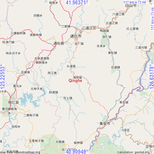
Qinghe GPS coordinates[2]
41° 26' 19.464" North, 125° 55' 43.14" East
| Map corner | latitude | longitude |
|---|---|---|
| Upper-left | 41.96371°, | 125.22553° |
| Center: | 41.43874°, | 125.92865° |
| Lower-right: | 40.90949°, | 126.63178° |
| Map W x H: | 117.2×117.2 km | = 72.8×72.8mi |
| max Lat: | 53.31946° ⇑10% North |
| Qinghe: | 41.43874° |
| min Lat: | ⇓90% South 18.22056° |
| min Long | Qinghe | max Long |
| 75.07348° | 125.92865° | 134.28917° |
| W 95.4%⇐ | ⇒4.6% E |
Elevation
Elevation of Qinghe is 414 m = 1358 ft, and this is 70.8 m = 232 ft below average elevation for this country.
| Max E: |
5622 m = 18445 ft | 29.9% |
| Avg. | 484.8 m = 1591 ft | |
| Qinghe | 414 m = 1358 ft | |
Min E: |
-3 m = -10 ft | 70.1% |
See also: China elevation on elevation.city.
Geographical zone
Qinghe is located in North temperate zone (between Tropic of Cancer and the Arctic Circle). Distance of this Northern Tropic circle is 2001.6 km =1243.7 mi to South.| Distance of | km | miles | from Qinghe |
|---|---|---|---|
| North Pole | 5399.5 | 3355.1 | to North |
| Arctic Circle | 2793.6 | 1735.9 | to North |
| Tropic Cancer | 2001.6 | 1243.7 | to South |
| Equator | 4607.6 | 2863 | to South |


Nearby cities:
15 places around Qinghe: (largest is in red/bold)
• Caiyuan
21.2 km =13.2 mi,  237°
237°
• Dachuan
34.6 km =21.5 mi,  290°
290°
• Daduling
28.1 km =17.5 mi,  315°
315°
• Daquanyuan
29.9 km =18.6 mi,  295°
295°
• Donglai
29.8 km =18.5 mi,  37°
37°
• Gongyi
30.3 km =18.8 mi,  75°
75°
• Huadian
20 km =12.4 mi,  219°
219°
• Jiangdianzi
18.3 km =11.4 mi,  280°
280°
• Jindou
35.6 km =22.1 mi,  326°
326°
• Kuaidamao
28.6 km =17.8 mi, 327°
• Liudaogou
32.9 km =20.4 mi,  55°
55°
• Qidaogou
33.4 km =20.8 mi,  68°
68°
• Taishang
17.2 km =10.7 mi,  204°
204°
• Tonghua
31.2 km =19.4 mi,  359°
359°
• Toudao
9.5 km =5.9 mi, 330°
Sources, notices
• [Note1] Compared only with cities in China existing in our database
• [Src1] Map data: © OpenStreetMap contributors (CC-BY-SA)
• [Src2] Other city data from geonames.org with taken over terms of usage.
• [Src3] Geographical zone / Annual Mean Temperature by Robert A. Rohde @ Wikipedia
