Hulutao geodata
Hulutao (Jilin) is a seat of a fourth-order administrative division; located in China in Asia/Shanghai (GMT+8) time zone. In our database, there are 1268 cities with bigger population. Compared to other cities in China, 90.7% of cities are located further ↓South; 95.5% of cities are located further ←West and 71.6% of cities have lower elevation than Hulutao. Note1


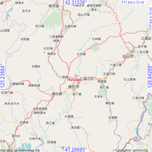
Hulutao GPS coordinates[2]
41° 47' 35.916" North, 125° 56' 23.136" East
| Map corner | latitude | longitude |
|---|---|---|
| Upper-left | 42.31538°, | 125.23664° |
| Center: | 41.79331°, | 125.93976° |
| Lower-right: | 41.26695°, | 126.64289° |
| Map W x H: | 116.6×116.6 km | = 72.5×72.5mi |
| max Lat: | 53.31946° ⇑9.3% North |
| Hulutao: | 41.79331° |
| min Lat: | ⇓90.7% South 18.22056° |
| min Long | Hulutao | max Long |
| 75.07348° | 125.93976° | 134.28917° |
| W 95.5%⇐ | ⇒4.5% E |
Elevation
Elevation of Hulutao is 443 m = 1453 ft, and this is 41.8 m = 137 ft below average elevation for this country.
| Max E: |
5622 m = 18445 ft | 28.4% |
| Avg. | 484.8 m = 1591 ft | |
| Hulutao | 443 m = 1453 ft | |
Min E: |
-3 m = -10 ft | 71.6% |
See also: China elevation on elevation.city.
Geographical zone
Hulutao is located in North temperate zone (between Tropic of Cancer and the Arctic Circle). Distance of this Northern Tropic circle is 2041.1 km =1268.3 mi to South.| Distance of | km | miles | from Hulutao |
|---|---|---|---|
| North Pole | 5360.1 | 3330.6 | to North |
| Arctic Circle | 2754.2 | 1711.4 | to North |
| Tropic Cancer | 2041.1 | 1268.3 | to South |
| Equator | 4647 | 2887.5 | to South |


Nearby cities:
15 places around Hulutao: (largest is in red/bold)
• Daduling
28.4 km =17.6 mi,  226°
226°
• Dahuanggou
32.5 km =20.2 mi,  28°
28°
• Da’an
16.2 km =10.1 mi,  73°
73°
• Donglai
23.1 km =14.4 mi,  132°
132°
• Erdaojiang
7.9 km =4.9 mi,  103°
103°
• Ermi
9.1 km =5.7 mi,  266°
266°
• Gangou
20.2 km =12.6 mi,  292°
292°
• Guanghua
17.4 km =10.8 mi,  12°
12°
• Jindou
22.9 km =14.2 mi,  244°
244°
• Kuaidamao
22.5 km =14 mi, 226°
• Sipeng
31.4 km =19.5 mi,  284°
284°
• Tonghua
8.3 km =5.2 mi,  187°
187°
• Tongshanjie
9.1 km =5.7 mi,  304°
304°
• Toudao
31.7 km =19.7 mi, 190°
• Ying’ebu
32.6 km =20.3 mi,  257°
257°
Sources, notices
• [Note1] Compared only with cities in China existing in our database
• [Src1] Map data: © OpenStreetMap contributors (CC-BY-SA)
• [Src2] Other city data from geonames.org with taken over terms of usage.
• [Src3] Geographical zone / Annual Mean Temperature by Robert A. Rohde @ Wikipedia
