Shengli geodata
Shengli (Heilongjiang) is a seat of a fourth-order administrative division; located in China in Asia/Shanghai (GMT+8) time zone. In our database, there are 1268 cities with bigger population. Compared to other cities in China, 95.8% of cities are located further ↓South; 93.4% of cities are located further ←West and 54.2% of cities have higher elevation than Shengli. Note1


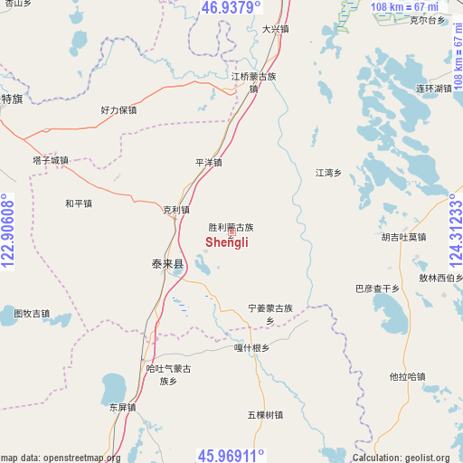
Shengli GPS coordinates[2]
46° 27' 20.376" North, 123° 36' 33.12" East
| Map corner | latitude | longitude |
|---|---|---|
| Upper-left | 46.9379°, | 122.90608° |
| Center: | 46.45566°, | 123.6092° |
| Lower-right: | 45.96911°, | 124.31233° |
| Map W x H: | 107.7×107.7 km | = 66.9×66.9mi |
| max Lat: | 53.31946° ⇑4.2% North |
| Shengli: | 46.45566° |
| min Lat: | ⇓95.8% South 18.22056° |
| min Long | Shengli | max Long |
| 75.07348° | 123.6092° | 134.28917° |
| W 93.4%⇐ | ⇒6.6% E |
Elevation
Elevation of Shengli is 136 m = 446 ft, and this is 348.8 m = 1144 ft below average elevation for this country.
| Max E: |
5622 m = 18445 ft | 54.2% |
| Avg. | 484.8 m = 1591 ft | |
| Shengli | 136 m = 446 ft | |
Min E: |
-3 m = -10 ft | 45.8% |
See also: China elevation on elevation.city.
Geographical zone
Shengli is located in North temperate zone (between Tropic of Cancer and the Arctic Circle). Distance of this North polar circle is 2235.8 km =1389.3 mi to North.| Distance of | km | miles | from Shengli |
|---|---|---|---|
| North Pole | 4841.7 | 3008.5 | to North |
| Arctic Circle | 2235.8 | 1389.3 | to North |
| Tropic Cancer | 2559.5 | 1590.4 | to South |
| Equator | 5165.4 | 3209.6 | to South |


Nearby cities:
15 places around Shengli: (largest is in red/bold)
• Baomin
35.4 km =22 mi,  226°
226°
• Bayan Qagan
35.9 km =22.3 mi,  111°
111°
• Dandai
26.9 km =16.7 mi,  138°
138°
• Ganq Ger
27.3 km =17 mi,  170°
170°
• Haoxin
15.9 km =9.9 mi,  193°
193°
• Heping
36.1 km =22.4 mi,  281°
281°
• Hongsheng
26.6 km =16.5 mi,  238°
238°
• Jiangqiao
35.3 km =21.9 mi,  8°
8°
• Jiangwan
26.5 km =16.5 mi,  57°
57°
• Keli
14.1 km =8.8 mi,  292°
292°
• Ningjiang
20.9 km =13 mi,  154°
154°
• Nuwen Muren
32.9 km =20.4 mi,  358°
358°
• Pingyang
17.1 km =10.6 mi,  341°
341°
• Siliwu
29.5 km =18.3 mi,  295°
295°
• Tailai
16.7 km =10.4 mi, 243°
Sources, notices
• [Note1] Compared only with cities in China existing in our database
• [Src1] Map data: © OpenStreetMap contributors (CC-BY-SA)
• [Src2] Other city data from geonames.org with taken over terms of usage.
• [Src3] Geographical zone / Annual Mean Temperature by Robert A. Rohde @ Wikipedia
