Ganq Ger geodata
Ganq Ger (Jilin) is a seat of a fourth-order administrative division; located in China in Asia/Shanghai (GMT+8) time zone. In our database, there are 1268 cities with bigger population. Compared to other cities in China, 95.4% of cities are located further ↓South; 93.4% of cities are located further ←West and 54.6% of cities have higher elevation than Ganq Ger. Note1


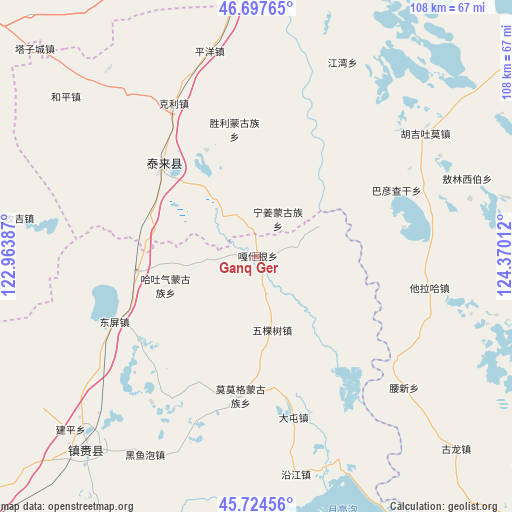
Ganq Ger GPS coordinates[2]
46° 12' 47.736" North, 123° 40' 1.164" East
| Map corner | latitude | longitude |
|---|---|---|
| Upper-left | 46.69765°, | 122.96387° |
| Center: | 46.21326°, | 123.66699° |
| Lower-right: | 45.72456°, | 124.37012° |
| Map W x H: | 108.2×108.2 km | = 67.2×67.2mi |
| max Lat: | 53.31946° ⇑4.6% North |
| Ganq Ger: | 46.21326° |
| min Lat: | ⇓95.4% South 18.22056° |
| min Long | Ganq Ger | max Long |
| 75.07348° | 123.66699° | 134.28917° |
| W 93.4%⇐ | ⇒6.6% E |
Elevation
Elevation of Ganq Ger is 134 m = 440 ft, and this is 350.8 m = 1151 ft below average elevation for this country.
| Max E: |
5622 m = 18445 ft | 54.6% |
| Avg. | 484.8 m = 1591 ft | |
| Ganq Ger | 134 m = 440 ft | |
Min E: |
-3 m = -10 ft | 45.4% |
See also: China elevation on elevation.city.
Geographical zone
Ganq Ger is located in North temperate zone (between Tropic of Cancer and the Arctic Circle). Distance of this North polar circle is 2262.7 km =1406 mi to North.| Distance of | km | miles | from Ganq Ger |
|---|---|---|---|
| North Pole | 4868.6 | 3025.2 | to North |
| Arctic Circle | 2262.7 | 1406 | to North |
| Tropic Cancer | 2532.5 | 1573.6 | to South |
| Equator | 5138.4 | 3192.9 | to South |


Nearby cities:
15 places around Ganq Ger: (largest is in red/bold)
• Baomin
30.1 km =18.7 mi,  274°
274°
• Bayan Qagan
32.2 km =20 mi,  64°
64°
• Dandai
14.9 km =9.3 mi, 63°
• Dongping
33.1 km =20.6 mi,  245°
245°
• Haoxin
14.1 km =8.8 mi,  324°
324°
• Hongsheng
30.3 km =18.8 mi,  295°
295°
• Hujil Tohom
44.3 km =27.5 mi,  53°
53°
• Keli
36.7 km =22.8 mi,  331°
331°
• Ningjiang
9.2 km =5.7 mi,  29°
29°
• Pingyang
44.3 km =27.5 mi,  347°
347°
• Shengli
27.3 km =17 mi, 350°
• Tailai
27.6 km =17.1 mi, 315°
• Talin Hiag
37 km =23 mi,  99°
99°
• Tantu
25.2 km =15.7 mi,  262°
262°
• Wukeshu
15.9 km =9.9 mi,  168°
168°
Sources, notices
• [Note1] Compared only with cities in China existing in our database
• [Src1] Map data: © OpenStreetMap contributors (CC-BY-SA)
• [Src2] Other city data from geonames.org with taken over terms of usage.
• [Src3] Geographical zone / Annual Mean Temperature by Robert A. Rohde @ Wikipedia
