Pingyang geodata
Pingyang (Heilongjiang) is a seat of a fourth-order administrative division; located in China in Asia/Shanghai (GMT+8) time zone. In our database, there are 1268 cities with bigger population. Compared to other cities in China, 98.8% of cities are located further ↓South; 94.2% of cities are located further ←West and 52.5% of cities have lower elevation than Pingyang. Note1


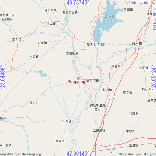
Pingyang GPS coordinates[2]
48° 16' 17.724" North, 124° 20' 53.196" East
| Map corner | latitude | longitude |
|---|---|---|
| Upper-left | 48.73745°, | 123.64499° |
| Center: | 48.27159°, | 124.34811° |
| Lower-right: | 47.80145°, | 125.05124° |
| Map W x H: | 104.1×104.1 km | = 64.7×64.7mi |
| max Lat: | 53.31946° ⇑1.2% North |
| Pingyang: | 48.27159° |
| min Lat: | ⇓98.8% South 18.22056° |
| min Long | Pingyang | max Long |
| 75.07348° | 124.34811° | 134.28917° |
| W 94.2%⇐ | ⇒5.8% E |
Elevation
Elevation of Pingyang is 185 m = 607 ft, and this is 299.8 m = 984 ft below average elevation for this country.
| Max E: |
5622 m = 18445 ft | 47.5% |
| Avg. | 484.8 m = 1591 ft | |
| Pingyang | 185 m = 607 ft | |
Min E: |
-3 m = -10 ft | 52.5% |
See also: China elevation on elevation.city.
Geographical zone
Pingyang is located in North temperate zone (between Tropic of Cancer and the Arctic Circle). Distance of this North polar circle is 2033.9 km =1263.8 mi to North.| Distance of | km | miles | from Pingyang |
|---|---|---|---|
| North Pole | 4639.8 | 2883 | to North |
| Arctic Circle | 2033.9 | 1263.8 | to North |
| Tropic Cancer | 2761.4 | 1715.9 | to South |
| Equator | 5367.3 | 3335.1 | to South |


Nearby cities:
15 places around Pingyang: (largest is in red/bold)
• Baoshan
33.8 km =21 mi,  241°
241°
• Baoshan
40.7 km =25.3 mi,  333°
333°
• Borong
17.4 km =10.8 mi,  38°
38°
• Chahayang
17.4 km =10.8 mi,  346°
346°
• Dengteke
38.8 km =24.1 mi,  20°
20°
• Dongyang
29.8 km =18.5 mi,  194°
194°
• Erdaowan
37.4 km =23.2 mi,  158°
158°
• Gushan
43.4 km =27 mi,  278°
278°
• Hangu Erhe
8.6 km =5.3 mi,  98°
98°
• Jubao
43.7 km =27.2 mi,  196°
196°
• Liuhe
33 km =20.5 mi,  296°
296°
• Nehe
42.9 km =26.7 mi,  56°
56°
• Nirji
25.6 km =15.9 mi, 22°
• Wu’erke
29.6 km =18.4 mi, 352°
• Xiwa’ertu
44.2 km =27.5 mi, 352°
Sources, notices
• [Note1] Compared only with cities in China existing in our database
• [Src1] Map data: © OpenStreetMap contributors (CC-BY-SA)
• [Src2] Other city data from geonames.org with taken over terms of usage.
• [Src3] Geographical zone / Annual Mean Temperature by Robert A. Rohde @ Wikipedia
