Baoshan geodata
Baoshan (Inner Mongolia) is a seat of a fourth-order administrative division; located in China in Asia/Shanghai (GMT+8) time zone. In our database, there are 1268 cities with bigger population. Compared to other cities in China, 98.9% of cities are located further ↓South; 93.9% of cities are located further ←West and 57.3% of cities have lower elevation than Baoshan. Note1


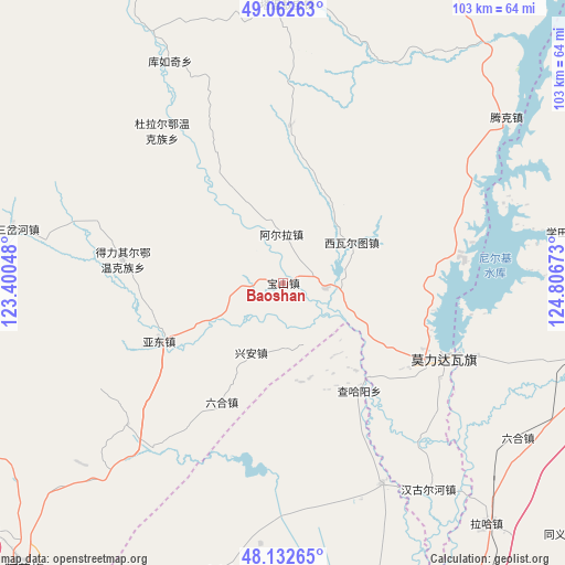
Baoshan GPS coordinates[2]
48° 35' 59.208" North, 124° 6' 12.96" East
| Map corner | latitude | longitude |
|---|---|---|
| Upper-left | 49.06263°, | 123.40048° |
| Center: | 48.59978°, | 124.1036° |
| Lower-right: | 48.13265°, | 124.80673° |
| Map W x H: | 103.4×103.4 km | = 64.2×64.2mi |
| max Lat: | 53.31946° ⇑1.1% North |
| Baoshan: | 48.59978° |
| min Lat: | ⇓98.9% South 18.22056° |
| min Long | Baoshan | max Long |
| 75.07348° | 124.1036° | 134.28917° |
| W 93.9%⇐ | ⇒6.1% E |
Elevation
Elevation of Baoshan is 228 m = 748 ft, and this is 256.8 m = 843 ft below average elevation for this country.
| Max E: |
5622 m = 18445 ft | 42.7% |
| Avg. | 484.8 m = 1591 ft | |
| Baoshan | 228 m = 748 ft | |
Min E: |
-3 m = -10 ft | 57.3% |
See also: China elevation on elevation.city.
Geographical zone
Baoshan is located in North temperate zone (between Tropic of Cancer and the Arctic Circle). Distance of this North polar circle is 1997.4 km =1241.1 mi to North.| Distance of | km | miles | from Baoshan |
|---|---|---|---|
| North Pole | 4603.3 | 2860.4 | to North |
| Arctic Circle | 1997.4 | 1241.1 | to North |
| Tropic Cancer | 2797.9 | 1738.5 | to South |
| Equator | 5403.8 | 3357.8 | to South |


Nearby cities:
15 places around Baoshan: (largest is in red/bold)
• A’erla
8.9 km =5.5 mi,  358°
358°
• Borong
36.7 km =22.8 mi,  128°
128°
• Chahayang
24 km =14.9 mi,  144°
144°
• Deliqi’er
28.6 km =17.8 mi,  277°
277°
• Dengteke
31.8 km =19.8 mi,  90°
90°
• Dula’er Ewenke Minzu
35.5 km =22.1 mi,  321°
321°
• Gushan
38.8 km =24.1 mi,  219°
219°
• Kunmi Erdi
29 km =18 mi,  2°
2°
• Liuhe
24.9 km =15.5 mi,  207°
207°
• Nirji
30.8 km =19.1 mi,  114°
114°
• Pingyang
40.7 km =25.3 mi,  153°
153°
• Taipingzhuang
40 km =24.9 mi,  244°
244°
• Wu’erke
15.7 km =9.8 mi,  117°
117°
• Xiwa’ertu
14.2 km =8.8 mi,  59°
59°
• Yadong
25.9 km =16.1 mi,  245°
245°
Sources, notices
• [Note1] Compared only with cities in China existing in our database
• [Src1] Map data: © OpenStreetMap contributors (CC-BY-SA)
• [Src2] Other city data from geonames.org with taken over terms of usage.
• [Src3] Geographical zone / Annual Mean Temperature by Robert A. Rohde @ Wikipedia
