Ning’an geodata
Ning’an (Heilongjiang) is a seat of a third-order administrative division; located in China in Asia/Shanghai (GMT+8) time zone. In our database, there are 1268 cities with bigger population. Compared to other cities in China, 93.2% of cities are located further ↓South; 98.7% of cities are located further ←West and 60% of cities have lower elevation than Ning’an. Note1


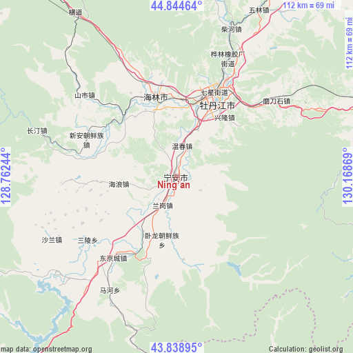
Ning’an GPS coordinates[2]
44° 20' 38.22" North, 129° 27' 56.016" East
| Map corner | latitude | longitude |
|---|---|---|
| Upper-left | 44.84464°, | 128.76244° |
| Center: | 44.34395°, | 129.46556° |
| Lower-right: | 43.83895°, | 130.16869° |
| Map W x H: | 111.8×111.8 km | = 69.5×69.5mi |
| max Lat: | 53.31946° ⇑6.8% North |
| Ning’an: | 44.34395° |
| min Lat: | ⇓93.2% South 18.22056° |
| min Long | Ning’an | max Long |
| 75.07348° | 129.46556° | 134.28917° |
| W 98.7%⇐ | ⇒1.3% E |
Elevation
Elevation of Ning’an is 259 m = 850 ft, and this is 225.8 m = 741 ft below average elevation for this country.
| Max E: |
5622 m = 18445 ft | 40% |
| Avg. | 484.8 m = 1591 ft | |
| Ning’an | 259 m = 850 ft | |
Min E: |
-3 m = -10 ft | 60% |
See also: China elevation on elevation.city.
Geographical zone
Ning’an is located in North temperate zone (between Tropic of Cancer and the Arctic Circle). Distance of this Northern Tropic circle is 2324.7 km =1444.5 mi to South.| Distance of | km | miles | from Ning’an |
|---|---|---|---|
| North Pole | 5076.5 | 3154.4 | to North |
| Arctic Circle | 2470.6 | 1535.2 | to North |
| Tropic Cancer | 2324.7 | 1444.5 | to South |
| Equator | 4930.6 | 3063.7 | to South |


Nearby cities:
15 places around Ning’an: (largest is in red/bold)
• Fanjia
3.8 km =2.4 mi,  4°
4°
• Hailang
18.6 km =11.6 mi,  263°
263°
• Hailin
26.1 km =16.2 mi,  345°
345°
• Hainan
24.5 km =15.2 mi, 4°
• Langang
10.1 km =6.3 mi,  207°
207°
• Ping’an
20.3 km =12.6 mi,  222°
222°
• Shihe
24.9 km =15.5 mi,  318°
318°
• Shiyan
21.3 km =13.2 mi, 209°
• Wenchun
9.7 km =6 mi,  10°
10°
• Wolong
20.4 km =12.7 mi,  193°
193°
• Xianfeng
27.9 km =17.3 mi,  22°
22°
• Xiangyang
28.6 km =17.8 mi, 18°
• Xinghua
27.7 km =17.2 mi,  240°
240°
• Xinglong
24.4 km =15.2 mi,  26°
26°
• Yanjiang
26.3 km =16.3 mi, 19°
Sources, notices
• [Note1] Compared only with cities in China existing in our database
• [Src1] Map data: © OpenStreetMap contributors (CC-BY-SA)
• [Src2] Other city data from geonames.org with taken over terms of usage.
• [Src3] Geographical zone / Annual Mean Temperature by Robert A. Rohde @ Wikipedia
