Shiyan geodata
Shiyan (Heilongjiang) is a seat of a fourth-order administrative division; located in China in Asia/Shanghai (GMT+8) time zone. In our database, there are 1268 cities with bigger population. Compared to other cities in China, 93% of cities are located further ↓South; 98.6% of cities are located further ←West and 64.1% of cities have lower elevation than Shiyan. Note1


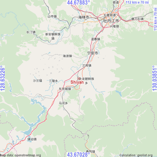
Shiyan GPS coordinates[2]
44° 10' 36.156" North, 129° 20' 7.368" East
| Map corner | latitude | longitude |
|---|---|---|
| Upper-left | 44.67883°, | 128.63226° |
| Center: | 44.17671°, | 129.33538° |
| Lower-right: | 43.67028°, | 130.03851° |
| Map W x H: | 112.1×112.1 km | = 69.7×69.7mi |
| max Lat: | 53.31946° ⇑7% North |
| Shiyan: | 44.17671° |
| min Lat: | ⇓93% South 18.22056° |
| min Long | Shiyan | max Long |
| 75.07348° | 129.33538° | 134.28917° |
| W 98.6%⇐ | ⇒1.4% E |
Elevation
Elevation of Shiyan is 312 m = 1024 ft, and this is 172.8 m = 567 ft below average elevation for this country.
| Max E: |
5622 m = 18445 ft | 35.9% |
| Avg. | 484.8 m = 1591 ft | |
| Shiyan | 312 m = 1024 ft | |
Min E: |
-3 m = -10 ft | 64.1% |
See also: China elevation on elevation.city.
Geographical zone
Shiyan is located in North temperate zone (between Tropic of Cancer and the Arctic Circle). Distance of this Northern Tropic circle is 2306.1 km =1432.9 mi to South.| Distance of | km | miles | from Shiyan |
|---|---|---|---|
| North Pole | 5095.1 | 3165.9 | to North |
| Arctic Circle | 2489.2 | 1546.7 | to North |
| Tropic Cancer | 2306.1 | 1432.9 | to South |
| Equator | 4912 | 3052.2 | to South |


Nearby cities:
15 places around Shiyan: (largest is in red/bold)
• Bohai
16.2 km =10.1 mi,  245°
245°
• Dongjingcheng
12.2 km =7.6 mi,  235°
235°
• Fanjia
24.8 km =15.4 mi,  25°
25°
• Hailang
18.4 km =11.4 mi,  333°
333°
• Jiujie
30.8 km =19.1 mi,  319°
319°
• Langang
11.2 km =7 mi, 30°
• Mahe
18.7 km =11.6 mi,  218°
218°
• Ning’an
21.3 km =13.2 mi, 29°
• Ping’an
4.8 km =3 mi, 316°
• Sanling
18.1 km =11.2 mi,  266°
266°
• Shalan
29.5 km =18.3 mi, 267°
• Wenchun
30.7 km =19.1 mi,  23°
23°
• Wolong
5.7 km =3.5 mi,  102°
102°
• Xinghua
14.6 km =9.1 mi,  289°
289°
• Xin’an
32.1 km =19.9 mi, 327°
Sources, notices
• [Note1] Compared only with cities in China existing in our database
• [Src1] Map data: © OpenStreetMap contributors (CC-BY-SA)
• [Src2] Other city data from geonames.org with taken over terms of usage.
• [Src3] Geographical zone / Annual Mean Temperature by Robert A. Rohde @ Wikipedia
