Dongbeicha geodata
Dongbeicha (Jilin) is a seat of a fourth-order administrative division; located in China in Asia/Shanghai (GMT+8) time zone. In our database, there are 1268 cities with bigger population. Compared to other cities in China, 90.5% of cities are located further ↓South; 97.2% of cities are located further ←West and 83.3% of cities have lower elevation than Dongbeicha. Note1


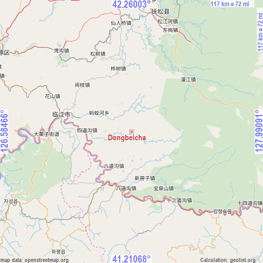
Dongbeicha GPS coordinates[2]
41° 44' 15" North, 127° 17' 16.008" East
| Map corner | latitude | longitude |
|---|---|---|
| Upper-left | 42.26003°, | 126.58466° |
| Center: | 41.7375°, | 127.28778° |
| Lower-right: | 41.21068°, | 127.99091° |
| Map W x H: | 116.7×116.7 km | = 72.5×72.5mi |
| max Lat: | 53.31946° ⇑9.5% North |
| Dongbeicha: | 41.7375° |
| min Lat: | ⇓90.5% South 18.22056° |
| min Long | Dongbeicha | max Long |
| 75.07348° | 127.28778° | 134.28917° |
| W 97.2%⇐ | ⇒2.8% E |
Elevation
Elevation of Dongbeicha is 869 m = 2851 ft, and this is 384.2 m = 1260 ft above average elevation for this country.
| Max E: |
5622 m = 18445 ft | 16.7% |
| Dongbeicha | 869 m 2851 ft | |
| Avg. | 484.8 m = 1591 ft | |
Min E: |
-3 m = -10 ft | 83.3% |
See also: China elevation on elevation.city.
Geographical zone
Dongbeicha is located in North temperate zone (between Tropic of Cancer and the Arctic Circle). Distance of this Northern Tropic circle is 2034.9 km =1264.4 mi to South.| Distance of | km | miles | from Dongbeicha |
|---|---|---|---|
| North Pole | 5366.3 | 3334.5 | to North |
| Arctic Circle | 2760.4 | 1715.2 | to North |
| Tropic Cancer | 2034.9 | 1264.4 | to South |
| Equator | 4640.8 | 2883.7 | to South |


Nearby cities:
15 places around Dongbeicha: (largest is in red/bold)
• Badaogou
24.6 km =15.3 mi,  184°
184°
• Baoquanshan
28.5 km =17.7 mi,  150°
150°
• Baoshan
13.2 km =8.2 mi, 178°
• Huashu
28.8 km =17.9 mi,  348°
348°
• Jiajiaying
10 km =6.2 mi,  305°
305°
• Linjiang
32.4 km =20.1 mi,  283°
283°
• Liudaogou
16.9 km =10.5 mi,  209°
209°
• Manjiang
34.3 km =21.3 mi,  47°
47°
• Mayihe
16.8 km =10.4 mi,  301°
301°
• Naozhi
30.3 km =18.8 mi, 313°
• Shi’erdaogou
37.1 km =23.1 mi,  144°
144°
• Sidaogou
19.6 km =12.2 mi,  272°
272°
• Songshu
37.2 km =23.1 mi,  336°
336°
• Xinfangzi
21.2 km =13.2 mi,  163°
163°
• Xinxigang
36.8 km =22.9 mi,  8°
8°
Sources, notices
• [Note1] Compared only with cities in China existing in our database
• [Src1] Map data: © OpenStreetMap contributors (CC-BY-SA)
• [Src2] Other city data from geonames.org with taken over terms of usage.
• [Src3] Geographical zone / Annual Mean Temperature by Robert A. Rohde @ Wikipedia
