Lianhe geodata
Lianhe (Heilongjiang) is a seat of a third-order administrative division; located in China in Asia/Shanghai (GMT+8) time zone. With population of 121,367 people, there are 364 cities with bigger population in this country. Compared to other cities in China, 97.2% of cities are located further ↓South; 98.6% of cities are located further ←West and 51% of cities have lower elevation than Lianhe. Note1


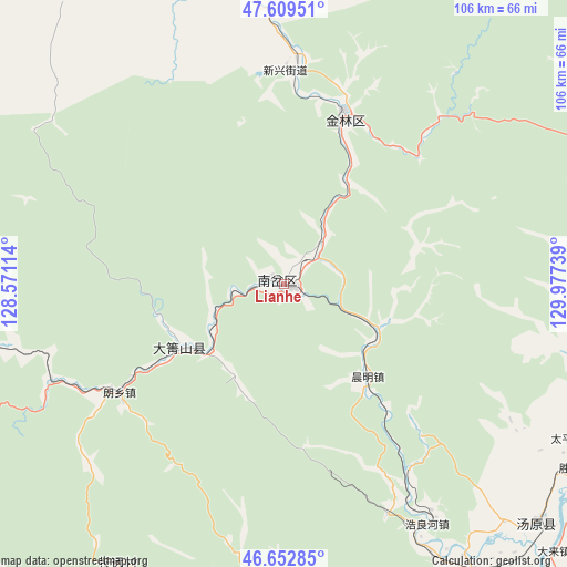
Lianhe GPS coordinates[2]
47° 7' 59.988" North, 129° 16' 27.336" East
| Map corner | latitude | longitude |
|---|---|---|
| Upper-left | 47.60951°, | 128.57114° |
| Center: | 47.13333°, | 129.27426° |
| Lower-right: | 46.65285°, | 129.97739° |
| Map W x H: | 106.4×106.4 km | = 66.1×66.1mi |
| max Lat: | 53.31946° ⇑2.8% North |
| Lianhe: | 47.13333° |
| min Lat: | ⇓97.2% South 18.22056° |
| min Long | Lianhe | max Long |
| 75.07348° | 129.27426° | 134.28917° |
| W 98.6%⇐ | ⇒1.4% E |
Elevation
Elevation of Lianhe is 173 m = 568 ft, and this is 311.8 m = 1023 ft below average elevation for this country.
| Max E: |
5622 m = 18445 ft | 49% |
| Avg. | 484.8 m = 1591 ft | |
| Lianhe | 173 m = 568 ft | |
Min E: |
-3 m = -10 ft | 51% |
See also: Lianhe elevation on elevation.city.
Geographical zone
Lianhe is located in North temperate zone (between Tropic of Cancer and the Arctic Circle). Distance of this North polar circle is 2160.4 km =1342.4 mi to North.| Distance of | km | miles | from Lianhe |
|---|---|---|---|
| North Pole | 4766.3 | 2961.6 | to North |
| Arctic Circle | 2160.4 | 1342.4 | to North |
| Tropic Cancer | 2634.8 | 1637.2 | to South |
| Equator | 5240.7 | 3256.4 | to South |


Nearby cities:
15 places around Lianhe: (largest is in red/bold)
• Chenming
23.6 km =14.7 mi,  137°
137°
• Dailing
22.8 km =14.2 mi,  237°
237°
• Fendou
32.8 km =20.4 mi,  20°
20°
• Haolianghe
52.7 km =32.7 mi,  149°
149°
• Hongqi
70.2 km =43.6 mi,  80°
80°
• Langxiang
36.9 km =22.9 mi, 236°
• Meixi
56.5 km =35.1 mi,  348°
348°
• Shengli
64.9 km =40.3 mi,  122°
122°
• Shenshu
68.2 km =42.4 mi,  251°
251°
• Taipingchuan
61.7 km =38.3 mi, 118°
• Tangwang
68.4 km =42.5 mi, 148°
• Tangyuan
65.6 km =40.8 mi,  133°
133°
• Xianglan
64.8 km =40.3 mi, 146°
• Xilin
38.2 km =23.7 mi,  3°
3°
• Yingchun
3.3 km =2.1 mi,  292°
292°
Sources, notices
• [Note1] Compared only with cities in China existing in our database
• [Src1] Map data: © OpenStreetMap contributors (CC-BY-SA)
• [Src2] Other city data from geonames.org with taken over terms of usage.
• [Src3] Geographical zone / Annual Mean Temperature by Robert A. Rohde @ Wikipedia
