Shengli geodata
Shengli (Heilongjiang) is a seat of a fourth-order administrative division; located in China in Asia/Shanghai (GMT+8) time zone. In our database, there are 1268 cities with bigger population. Compared to other cities in China, 96.6% of cities are located further ↓South; 99.1% of cities are located further ←West and 60.9% of cities have higher elevation than Shengli. Note1


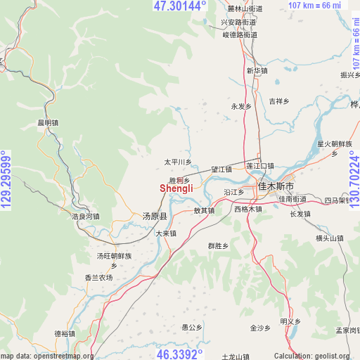
Shengli GPS coordinates[2]
46° 49' 20.892" North, 129° 59' 56.796" East
| Map corner | latitude | longitude |
|---|---|---|
| Upper-left | 47.30144°, | 129.29599° |
| Center: | 46.82247°, | 129.99911° |
| Lower-right: | 46.3392°, | 130.70224° |
| Map W x H: | 107×107 km | = 66.5×66.5mi |
| max Lat: | 53.31946° ⇑3.4% North |
| Shengli: | 46.82247° |
| min Lat: | ⇓96.6% South 18.22056° |
| min Long | Shengli | max Long |
| 75.07348° | 129.99911° | 134.28917° |
| W 99.1%⇐ | ⇒0.90000000000001% E |
Elevation
Elevation of Shengli is 93 m = 305 ft, and this is 391.8 m = 1285 ft below average elevation for this country.
| Max E: |
5622 m = 18445 ft | 60.9% |
| Avg. | 484.8 m = 1591 ft | |
| Shengli | 93 m = 305 ft | |
Min E: |
-3 m = -10 ft | 39.1% |
See also: China elevation on elevation.city.
Geographical zone
Shengli is located in North temperate zone (between Tropic of Cancer and the Arctic Circle). Distance of this North polar circle is 2195 km =1363.9 mi to North.| Distance of | km | miles | from Shengli |
|---|---|---|---|
| North Pole | 4800.9 | 2983.1 | to North |
| Arctic Circle | 2195 | 1363.9 | to North |
| Tropic Cancer | 2600.3 | 1615.8 | to South |
| Equator | 5206.2 | 3235 | to South |


Nearby cities:
15 places around Shengli: (largest is in red/bold)
• Aoqi
11.4 km =7.1 mi,  141°
141°
• Changqing
22.3 km =13.9 mi,  95°
95°
• Dalai
16.1 km =10 mi,  194°
194°
• Jiamusi
24.3 km =15.1 mi, 96°
• Lianjiangkou
23.9 km =14.9 mi,  79°
79°
• Ping’an
25.1 km =15.6 mi, 76°
• Qunsheng
22.5 km =14 mi,  149°
149°
• Taipingchuan
5.6 km =3.5 mi,  354°
354°
• Tangyuan
13.1 km =8.1 mi,  215°
215°
• Wangjiang
12.8 km =8 mi,  73°
73°
• Xianglan
27 km =16.8 mi, 224°
• Xigemu
21.9 km =13.6 mi,  112°
112°
• Yanjiang
16.4 km =10.2 mi, 101°
• Youyi
24.4 km =15.2 mi,  94°
94°
• Zhulian
26.7 km =16.6 mi,  202°
202°
Sources, notices
• [Note1] Compared only with cities in China existing in our database
• [Src1] Map data: © OpenStreetMap contributors (CC-BY-SA)
• [Src2] Other city data from geonames.org with taken over terms of usage.
• [Src3] Geographical zone / Annual Mean Temperature by Robert A. Rohde @ Wikipedia
