Liulimiao geodata
Liulimiao (Beijing) is a seat of a fourth-order administrative division; located in China in Asia/Shanghai (GMT+8) time zone. In our database, there are 1268 cities with bigger population. Compared to other cities in China, 88.3% of cities are located further ↓South; 63.9% of cities are located further ←West and 62.4% of cities have lower elevation than Liulimiao. Note1


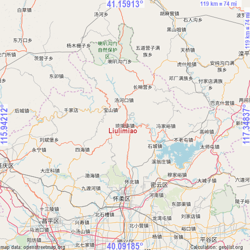
Liulimiao GPS coordinates[2]
40° 37' 39.432" North, 116° 38' 42.864" East
| Map corner | latitude | longitude |
|---|---|---|
| Upper-left | 41.15913°, | 115.94212° |
| Center: | 40.62762°, | 116.64524° |
| Lower-right: | 40.09185°, | 117.34837° |
| Map W x H: | 118.7×118.7 km | = 73.8×73.8mi |
| max Lat: | 53.31946° ⇑11.7% North |
| Liulimiao: | 40.62762° |
| min Lat: | ⇓88.3% South 18.22056° |
| min Long | Liulimiao | max Long |
| 75.07348° | 116.64524° | 134.28917° |
| W 63.9%⇐ | ⇒36.1% E |
Elevation
Elevation of Liulimiao is 288 m = 945 ft, and this is 196.8 m = 646 ft below average elevation for this country.
| Max E: |
5622 m = 18445 ft | 37.6% |
| Avg. | 484.8 m = 1591 ft | |
| Liulimiao | 288 m = 945 ft | |
Min E: |
-3 m = -10 ft | 62.4% |
See also: China elevation on elevation.city.
Geographical zone
Liulimiao is located in North temperate zone (between Tropic of Cancer and the Arctic Circle). Distance of this Northern Tropic circle is 1911.4 km =1187.7 mi to South.| Distance of | km | miles | from Liulimiao |
|---|---|---|---|
| North Pole | 5489.7 | 3411.1 | to North |
| Arctic Circle | 2883.8 | 1791.9 | to North |
| Tropic Cancer | 1911.4 | 1187.7 | to South |
| Equator | 4517.4 | 2807 | to South |


Nearby cities:
15 places around Liulimiao: (largest is in red/bold)
• Baoshan
10.3 km =6.4 mi,  316°
316°
• Bohai
28.3 km =17.6 mi,  211°
211°
• Bulaotun
28.6 km =17.8 mi,  103°
103°
• Changshaoying
20.2 km =12.6 mi,  23°
23°
• Huaibei
26.6 km =16.5 mi,  170°
170°
• Laba Goumen
30.1 km =18.7 mi,  355°
355°
• Qianjiadian
26.6 km =16.5 mi,  286°
286°
• Shicheng
17.2 km =10.7 mi,  124°
124°
• Shilibu
32.5 km =20.2 mi,  156°
156°
• Sihai
23.3 km =14.5 mi,  240°
240°
• Tanghekou
11.9 km =7.4 mi, 356°
• Xitiangezhuang
26.9 km =16.7 mi, 157°
• Xiwengzhuang
24 km =14.9 mi,  137°
137°
• Yanqi
29.6 km =18.4 mi,  178°
178°
• Zhenzhuquan
20.8 km =12.9 mi,  247°
247°
Sources, notices
• [Note1] Compared only with cities in China existing in our database
• [Src1] Map data: © OpenStreetMap contributors (CC-BY-SA)
• [Src2] Other city data from geonames.org with taken over terms of usage.
• [Src3] Geographical zone / Annual Mean Temperature by Robert A. Rohde @ Wikipedia
