Huanan geodata
Huanan (Heilongjiang) is a seat of a third-order administrative division; located in China in Asia/Shanghai (GMT+8) time zone. With population of 66,087 people, there are 653 cities with bigger population in this country. Compared to other cities in China, 95.4% of cities are located further ↓South; 99.6% of cities are located further ←West and 50.7% of cities have lower elevation than Huanan. Note1


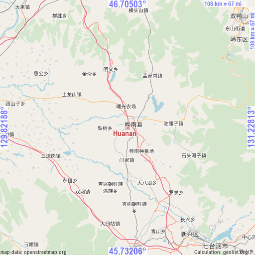
Huanan GPS coordinates[2]
46° 13' 14.52" North, 130° 31' 30" East
| Map corner | latitude | longitude |
|---|---|---|
| Upper-left | 46.70503°, | 129.82188° |
| Center: | 46.2207°, | 130.525° |
| Lower-right: | 45.73206°, | 131.22813° |
| Map W x H: | 108.2×108.2 km | = 67.2×67.2mi |
| max Lat: | 53.31946° ⇑4.6% North |
| Huanan: | 46.2207° |
| min Lat: | ⇓95.4% South 18.22056° |
| min Long | Huanan | max Long |
| 75.07348° | 130.525° | 134.28917° |
| W 99.6%⇐ | ⇒0.40000000000001% E |
Elevation
Elevation of Huanan is 171 m = 561 ft, and this is 313.8 m = 1030 ft below average elevation for this country.
| Max E: |
5622 m = 18445 ft | 49.3% |
| Avg. | 484.8 m = 1591 ft | |
| Huanan | 171 m = 561 ft | |
Min E: |
-3 m = -10 ft | 50.7% |
See also: Huanan elevation on elevation.city.
Geographical zone
Huanan is located in North temperate zone (between Tropic of Cancer and the Arctic Circle). Distance of this North polar circle is 2261.9 km =1405.5 mi to North.| Distance of | km | miles | from Huanan |
|---|---|---|---|
| North Pole | 4867.8 | 3024.7 | to North |
| Arctic Circle | 2261.9 | 1405.5 | to North |
| Tropic Cancer | 2533.3 | 1574.1 | to South |
| Equator | 5139.3 | 3193.4 | to South |


Nearby cities:
15 places around Huanan: (largest is in red/bold)
• Jixing
26.3 km =16.3 mi,  196°
196°
• Lishu
9.7 km =6 mi,  271°
271°
• Mengjiagang
24.7 km =15.3 mi,  24°
24°
• Mingyi
25.9 km =16.1 mi,  344°
344°
• Qiangken
38 km =23.6 mi,  163°
163°
• Qingfa
34.1 km =21.2 mi,  292°
292°
• Sandaogang
34.5 km =21.4 mi,  249°
249°
• Shitouhe
30.2 km =18.8 mi,  112°
112°
• Shuanghe
33.1 km =20.6 mi,  215°
215°
• Tulongshan
27.7 km =17.2 mi,  300°
300°
• Tuoyaozi
19.5 km =12.1 mi,  84°
84°
• Woken
24.6 km =15.3 mi,  182°
182°
• Xingshu
33.5 km =20.8 mi, 175°
• Yanjia
13.4 km =8.3 mi, 183°
• Yongheng
34.1 km =21.2 mi,  234°
234°
Sources, notices
• [Note1] Compared only with cities in China existing in our database
• [Src1] Map data: © OpenStreetMap contributors (CC-BY-SA)
• [Src2] Other city data from geonames.org with taken over terms of usage.
• [Src3] Geographical zone / Annual Mean Temperature by Robert A. Rohde @ Wikipedia
