Mingyi geodata
Mingyi (Heilongjiang) is a seat of a fourth-order administrative division; located in China in Asia/Shanghai (GMT+8) time zone. In our database, there are 1268 cities with bigger population. Compared to other cities in China, 95.8% of cities are located further ↓South; 99.5% of cities are located further ←West and 50.2% of cities have lower elevation than Mingyi. Note1


Mingyi GPS coordinates[2]
46° 26' 40.884" North, 130° 25' 58.152" East
| Map corner | latitude | longitude |
|---|---|---|
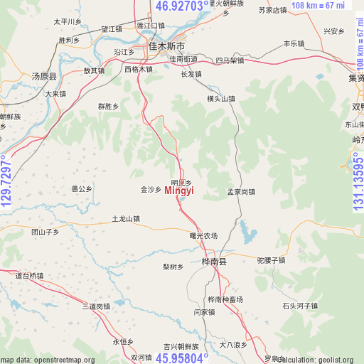
| Upper-left | 46.92703°, | 129.7297° |
| Center: | 46.44469°, | 130.43282° |
| Lower-right: | 45.95804°, | 131.13595° |
| Map W x H: | 107.7×107.7 km | = 66.9×66.9mi |
| max Lat: | 53.31946° ⇑4.2% North |
| Mingyi: | 46.44469° |
| min Lat: | ⇓95.8% South 18.22056° |
| min Long | Mingyi | max Long |
| 75.07348° | 130.43282° | 134.28917° |
| W 99.5%⇐ | ⇒0.5% E |
Elevation
Elevation of Mingyi is 167 m = 548 ft, and this is 317.8 m = 1043 ft below average elevation for this country.
| Max E: |
5622 m = 18445 ft | 49.8% |
| Avg. | 484.8 m = 1591 ft | |
| Mingyi | 167 m = 548 ft | |
Min E: |
-3 m = -10 ft | 50.2% |
See also: China elevation on elevation.city.
Geographical zone
Mingyi is located in North temperate zone (between Tropic of Cancer and the Arctic Circle). Distance of this North polar circle is 2237 km =1390 mi to North.| Distance of | km | miles | from Mingyi |
|---|---|---|---|
| North Pole | 4842.9 | 3009.2 | to North |
| Arctic Circle | 2237 | 1390 | to North |
| Tropic Cancer | 2558.2 | 1589.6 | to South |
| Equator | 5164.2 | 3208.9 | to South |


Nearby cities:
15 places around Mingyi: (largest is in red/bold)
• Changfa
32.1 km =19.9 mi,  4°
4°
• Hengtoushan
27.5 km =17.1 mi,  24°
24°
• Huanan
25.9 km =16.1 mi,  164°
164°
• Lishu
24.8 km =15.4 mi,  185°
185°
• Mengjiagang
17.6 km =10.9 mi,  98°
98°
• Qiaonan
40.3 km =25 mi,  351°
351°
• Qingfa
27.3 km =17 mi,  243°
243°
• Qunsheng
31.3 km =19.4 mi,  316°
316°
• Simajia
38.9 km =24.2 mi, 21°
• Tulongshan
19.8 km =12.3 mi, 237°
• Tuoyaozi
35.1 km =21.8 mi,  130°
130°
• Xigemu
36 km =22.4 mi,  339°
339°
• Yanjia
38.8 km =24.1 mi,  170°
170°
• Yugong
29.6 km =18.4 mi,  266°
266°
• Zhanqian
39.8 km =24.7 mi, 353°
Sources, notices
• [Note1] Compared only with cities in China existing in our database
• [Src1] Map data: © OpenStreetMap contributors (CC-BY-SA)
• [Src2] Other city data from geonames.org with taken over terms of usage.
• [Src3] Geographical zone / Annual Mean Temperature by Robert A. Rohde @ Wikipedia
