Qiangken geodata
Qiangken (Heilongjiang) is a seat of a fourth-order administrative division; located in China in Asia/Shanghai (GMT+8) time zone. In our database, there are 1268 cities with bigger population. Compared to other cities in China, 94.8% of cities are located further ↓South; 99.7% of cities are located further ←West and 51.7% of cities have lower elevation than Qiangken. Note1


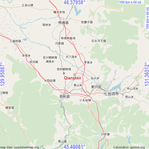
Qiangken GPS coordinates[2]
45° 53' 32.46" North, 130° 39' 43.164" East
| Map corner | latitude | longitude |
|---|---|---|
| Upper-left | 46.37958°, | 129.95887° |
| Center: | 45.89235°, | 130.66199° |
| Lower-right: | 45.40081°, | 131.36512° |
| Map W x H: | 108.8×108.8 km | = 67.6×67.6mi |
| max Lat: | 53.31946° ⇑5.2% North |
| Qiangken: | 45.89235° |
| min Lat: | ⇓94.8% South 18.22056° |
| min Long | Qiangken | max Long |
| 75.07348° | 130.66199° | 134.28917° |
| W 99.7%⇐ | ⇒0.3% E |
Elevation
Elevation of Qiangken is 179 m = 587 ft, and this is 305.8 m = 1003 ft below average elevation for this country.
| Max E: |
5622 m = 18445 ft | 48.3% |
| Avg. | 484.8 m = 1591 ft | |
| Qiangken | 179 m = 587 ft | |
Min E: |
-3 m = -10 ft | 51.7% |
See also: China elevation on elevation.city.
Geographical zone
Qiangken is located in North temperate zone (between Tropic of Cancer and the Arctic Circle). Distance of this North polar circle is 2298.4 km =1428.2 mi to North.| Distance of | km | miles | from Qiangken |
|---|---|---|---|
| North Pole | 4904.3 | 3047.4 | to North |
| Arctic Circle | 2298.4 | 1428.2 | to North |
| Tropic Cancer | 2496.8 | 1551.4 | to South |
| Equator | 5102.8 | 3170.7 | to South |


Nearby cities:
15 places around Qiangken: (largest is in red/bold)
• Beishan
22.3 km =13.9 mi,  112°
112°
• Boli
17 km =10.6 mi,  204°
204°
• Dasizhan
18.6 km =11.6 mi,  257°
257°
• Hongqi
18.5 km =11.5 mi,  119°
119°
• Huanan
38 km =23.6 mi,  343°
343°
• Jixing
21.2 km =13.2 mi,  302°
302°
• Qingshan
7.7 km =4.8 mi,  162°
162°
• Shitouhe
30.5 km =19 mi,  34°
34°
• Shuanghe
31.3 km =19.4 mi,  287°
287°
• Taihecun
20.5 km =12.7 mi,  134°
134°
• Wanbaohe
27 km =16.8 mi, 118°
• Woken
16.6 km =10.3 mi,  315°
315°
• Xiaowuzhan
20.1 km =12.5 mi, 156°
• Xingshu
8.3 km =5.2 mi, 292°
• Yanjia
25.8 km =16 mi,  333°
333°
Sources, notices
• [Note1] Compared only with cities in China existing in our database
• [Src1] Map data: © OpenStreetMap contributors (CC-BY-SA)
• [Src2] Other city data from geonames.org with taken over terms of usage.
• [Src3] Geographical zone / Annual Mean Temperature by Robert A. Rohde @ Wikipedia
