Heihe geodata
Heihe (Heilongjiang) is a populated place; located in China in Asia/Shanghai (GMT+8) time zone. With population of 109,427 people, there are 400 cities with bigger population in this country. Compared to other cities in China, 99.6% of cities are located further ↓South; 97.5% of cities are located further ←West and 53.7% of cities have higher elevation than Heihe. Note1


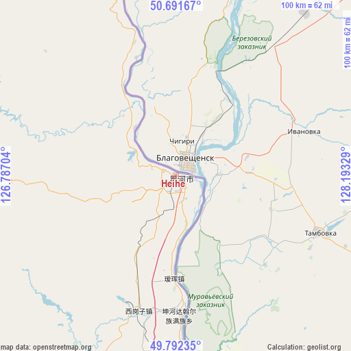
Heihe GPS coordinates[2]
50° 14' 38.868" North, 127° 29' 24.576" East
| Map corner | latitude | longitude |
|---|---|---|
| Upper-left | 50.69167°, | 126.78704° |
| Center: | 50.24413°, | 127.49016° |
| Lower-right: | 49.79235°, | 128.19329° |
| Map W x H: | 100×100 km | = 62.1×62.1mi |
| max Lat: | 53.31946° ⇑0.4% North |
| Heihe: | 50.24413° |
| min Lat: | ⇓99.6% South 18.22056° |
| min Long | Heihe | max Long |
| 75.07348° | 127.49016° | 134.28917° |
| W 97.5%⇐ | ⇒2.5% E |
Elevation
Elevation of Heihe is 139 m = 456 ft, and this is 345.8 m = 1135 ft below average elevation for this country.
| Max E: |
5622 m = 18445 ft | 53.7% |
| Avg. | 484.8 m = 1591 ft | |
| Heihe | 139 m = 456 ft | |
Min E: |
-3 m = -10 ft | 46.3% |
See also: Heihe elevation on elevation.city.
Geographical zone
Heihe is located in North temperate zone (between Tropic of Cancer and the Arctic Circle). Distance of this North polar circle is 1814.6 km =1127.5 mi to North.| Distance of | km | miles | from Heihe |
|---|---|---|---|
| North Pole | 4420.4 | 2746.7 | to North |
| Arctic Circle | 1814.6 | 1127.5 | to North |
| Tropic Cancer | 2980.7 | 1852.1 | to South |
| Equator | 5586.6 | 3471.4 | to South |


Nearby cities:
15 places around Heihe: (largest is in red/bold)
• Aihui
29.4 km =18.3 mi,  181°
181°
• Erzhan
74.2 km =46.1 mi,  211°
211°
• Kunheda Woerzu Manzu
40 km =24.9 mi, 178°
• Shangmachang
18.3 km =11.4 mi,  320°
320°
• Sijiazi
7.5 km =4.7 mi,  168°
168°
• Sunwu
92.8 km =57.7 mi,  187°
187°
• Woniuhe
81.6 km =50.7 mi,  198°
198°
• Xifengshan
51.5 km =32 mi,  313°
313°
• Xigangzi
40.1 km =24.9 mi, 195°
• Xinfu
0.7 km =0.4 mi, 181°
• Xing’an
0.5 km =0.3 mi,  28°
28°
• Xinsheng Elunchunzu
57.7 km =35.9 mi,  300°
300°
• Yanjiang
77.5 km =48.2 mi,  164°
164°
• Yaotun
90 km =55.9 mi, 179°
• Zhangdiyingzi
35.6 km =22.1 mi,  341°
341°
Sources, notices
• [Note1] Compared only with cities in China existing in our database
• [Src1] Map data: © OpenStreetMap contributors (CC-BY-SA)
• [Src2] Other city data from geonames.org with taken over terms of usage.
• [Src3] Geographical zone / Annual Mean Temperature by Robert A. Rohde @ Wikipedia
