Zhenluoying geodata
Zhenluoying (Beijing) is a seat of a fourth-order administrative division; located in China in Asia/Shanghai (GMT+8) time zone. In our database, there are 1268 cities with bigger population. Compared to other cities in China, 87.6% of cities are located further ↓South; 66.6% of cities are located further ←West and 61.3% of cities have lower elevation than Zhenluoying. Note1


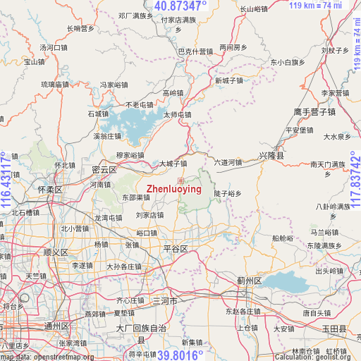
Zhenluoying GPS coordinates[2]
40° 20' 22.776" North, 117° 8' 3.444" East
| Map corner | latitude | longitude |
|---|---|---|
| Upper-left | 40.87347°, | 116.43117° |
| Center: | 40.33966°, | 117.13429° |
| Lower-right: | 39.8016°, | 117.83742° |
| Map W x H: | 119.2×119.2 km | = 74.1×74.1mi |
| max Lat: | 53.31946° ⇑12.4% North |
| Zhenluoying: | 40.33966° |
| min Lat: | ⇓87.6% South 18.22056° |
| min Long | Zhenluoying | max Long |
| 75.07348° | 117.13429° | 134.28917° |
| W 66.6%⇐ | ⇒33.4% E |
Elevation
Elevation of Zhenluoying is 275 m = 902 ft, and this is 209.8 m = 688 ft below average elevation for this country.
| Max E: |
5622 m = 18445 ft | 38.7% |
| Avg. | 484.8 m = 1591 ft | |
| Zhenluoying | 275 m = 902 ft | |
Min E: |
-3 m = -10 ft | 61.3% |
See also: China elevation on elevation.city.
Geographical zone
Zhenluoying is located in North temperate zone (between Tropic of Cancer and the Arctic Circle). Distance of this Northern Tropic circle is 1879.4 km =1167.8 mi to South.| Distance of | km | miles | from Zhenluoying |
|---|---|---|---|
| North Pole | 5521.7 | 3431 | to North |
| Arctic Circle | 2915.8 | 1811.8 | to North |
| Tropic Cancer | 1879.4 | 1167.8 | to South |
| Equator | 4485.3 | 2787 | to South |


Nearby cities:
15 places around Zhenluoying: (largest is in red/bold)
• Beizhuang
18.9 km =11.7 mi,  8°
8°
• Binhe
23 km =14.3 mi,  185°
185°
• Dachengzi
6.4 km =4 mi,  336°
336°
• Dahuashan
9.1 km =5.7 mi,  218°
218°
• Daxingzhuang
22.7 km =14.1 mi,  199°
199°
• Dongshaoqu
16 km =9.9 mi,  249°
249°
• Jinhaihu
21.2 km =13.2 mi,  146°
146°
• Jugezhuang
16.1 km =10 mi,  284°
284°
• Machangying
24.6 km =15.3 mi, 204°
• Nandulehe
20 km =12.4 mi,  160°
160°
• Shandongzhuang
16.7 km =10.4 mi,  172°
172°
• Taishitun
22.1 km =13.7 mi,  356°
356°
• Wangxingzhuang
20.3 km =12.6 mi, 187°
• Xiong’erzhai
6.9 km =4.3 mi, 187°
• Yukou
20.2 km =12.6 mi,  213°
213°
Sources, notices
• [Note1] Compared only with cities in China existing in our database
• [Src1] Map data: © OpenStreetMap contributors (CC-BY-SA)
• [Src2] Other city data from geonames.org with taken over terms of usage.
• [Src3] Geographical zone / Annual Mean Temperature by Robert A. Rohde @ Wikipedia
