Daxingzhuang geodata
Daxingzhuang (Beijing) is a seat of a fourth-order administrative division; located in China in Asia/Shanghai (GMT+8) time zone. In our database, there are 1268 cities with bigger population. Compared to other cities in China, 87% of cities are located further ↓South; 66.2% of cities are located further ←West and 76.7% of cities have higher elevation than Daxingzhuang. Note1


Daxingzhuang GPS coordinates[2]
40° 8' 49.272" North, 117° 2' 43.368" East
| Map corner | latitude | longitude |
|---|---|---|
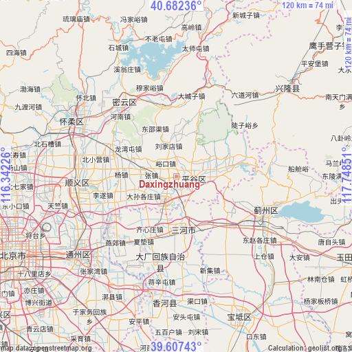
| Upper-left | 40.68236°, | 116.34226° |
| Center: | 40.14702°, | 117.04538° |
| Lower-right: | 39.60743°, | 117.74851° |
| Map W x H: | 119.5×119.5 km | = 74.3×74.3mi |
| max Lat: | 53.31946° ⇑13% North |
| Daxingzhuang: | 40.14702° |
| min Lat: | ⇓87% South 18.22056° |
| min Long | Daxingzhuang | max Long |
| 75.07348° | 117.04538° | 134.28917° |
| W 66.2%⇐ | ⇒33.8% E |
Elevation
Elevation of Daxingzhuang is 33 m = 108 ft, and this is 451.8 m = 1482 ft below average elevation for this country.
| Max E: |
5622 m = 18445 ft | 76.7% |
| Avg. | 484.8 m = 1591 ft | |
| Daxingzhuang | 33 m = 108 ft | |
Min E: |
-3 m = -10 ft | 23.3% |
See also: China elevation on elevation.city.
Geographical zone
Daxingzhuang is located in North temperate zone (between Tropic of Cancer and the Arctic Circle). Distance of this Northern Tropic circle is 1858 km =1154.5 mi to South.| Distance of | km | miles | from Daxingzhuang |
|---|---|---|---|
| North Pole | 5543.1 | 3444.3 | to North |
| Arctic Circle | 2937.2 | 1825.1 | to North |
| Tropic Cancer | 1858 | 1154.5 | to South |
| Equator | 4463.9 | 2773.7 | to South |


Nearby cities:
15 places around Daxingzhuang: (largest is in red/bold)
• Binhe
5.6 km =3.5 mi,  105°
105°
• Dahuashan
14.4 km =8.9 mi,  7°
7°
• Donggaocun
7.2 km =4.5 mi,  128°
128°
• Dongshaoqu
17.5 km =10.9 mi,  334°
334°
• Jinhaihu
19.8 km =12.3 mi,  78°
78°
• Longwantun
18.1 km =11.2 mi,  297°
297°
• Machangying
2.8 km =1.7 mi,  248°
248°
• Mafang
8 km =5 mi,  202°
202°
• Nandulehe
14.5 km =9 mi, 79°
• Shandongzhuang
10.8 km =6.7 mi,  63°
63°
• Wangxingzhuang
5 km =3.1 mi,  74°
74°
• Xiong’erzhai
16 km =9.9 mi,  24°
24°
• Yangzhen
19.4 km =12.1 mi,  271°
271°
• Yukou
5.9 km =3.7 mi,  321°
321°
• Zhangzhen
8.4 km =5.2 mi, 269°
Sources, notices
• [Note1] Compared only with cities in China existing in our database
• [Src1] Map data: © OpenStreetMap contributors (CC-BY-SA)
• [Src2] Other city data from geonames.org with taken over terms of usage.
• [Src3] Geographical zone / Annual Mean Temperature by Robert A. Rohde @ Wikipedia
