Nandulehe geodata
Nandulehe (Beijing) is a seat of a fourth-order administrative division; located in China in Asia/Shanghai (GMT+8) time zone. In our database, there are 1268 cities with bigger population. Compared to other cities in China, 87.1% of cities are located further ↓South; 67.3% of cities are located further ←West and 69.5% of cities have higher elevation than Nandulehe. Note1


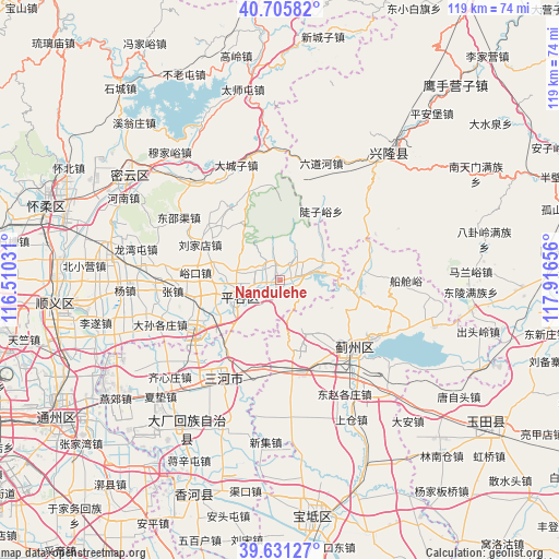
Nandulehe GPS coordinates[2]
40° 10' 14.412" North, 117° 12' 48.348" East
| Map corner | latitude | longitude |
|---|---|---|
| Upper-left | 40.70582°, | 116.51031° |
| Center: | 40.17067°, | 117.21343° |
| Lower-right: | 39.63127°, | 117.91656° |
| Map W x H: | 119.5×119.5 km | = 74.3×74.3mi |
| max Lat: | 53.31946° ⇑12.9% North |
| Nandulehe: | 40.17067° |
| min Lat: | ⇓87.1% South 18.22056° |
| min Long | Nandulehe | max Long |
| 75.07348° | 117.21343° | 134.28917° |
| W 67.3%⇐ | ⇒32.7% E |
Elevation
Elevation of Nandulehe is 54 m = 177 ft, and this is 430.8 m = 1413 ft below average elevation for this country.
| Max E: |
5622 m = 18445 ft | 69.5% |
| Avg. | 484.8 m = 1591 ft | |
| Nandulehe | 54 m = 177 ft | |
Min E: |
-3 m = -10 ft | 30.5% |
See also: China elevation on elevation.city.
Geographical zone
Nandulehe is located in North temperate zone (between Tropic of Cancer and the Arctic Circle). Distance of this Northern Tropic circle is 1860.6 km =1156.1 mi to South.| Distance of | km | miles | from Nandulehe |
|---|---|---|---|
| North Pole | 5540.5 | 3442.7 | to North |
| Arctic Circle | 2934.6 | 1823.5 | to North |
| Tropic Cancer | 1860.6 | 1156.1 | to South |
| Equator | 4466.6 | 2775.4 | to South |


Nearby cities:
15 places around Nandulehe: (largest is in red/bold)
• Baijian
19.6 km =12.2 mi,  181°
181°
• Bangjun
20.4 km =12.7 mi,  168°
168°
• Binhe
9.8 km =6.1 mi,  245°
245°
• Dahuashan
17.1 km =10.6 mi,  313°
313°
• Daxingzhuang
14.5 km =9 mi,  259°
259°
• Donggaocun
11.2 km =7 mi,  230°
230°
• Jinhaihu
5.3 km =3.3 mi,  77°
77°
• Lizhuangzi
22.5 km =14 mi,  158°
158°
• Machangying
17.2 km =10.7 mi, 257°
• Mafang
20 km =12.4 mi,  239°
239°
• Shandongzhuang
5.2 km =3.2 mi,  295°
295°
• Wangxingzhuang
9.5 km =5.9 mi, 262°
• Xiong’erzhai
14.1 km =8.8 mi,  327°
327°
• Yukou
18 km =11.2 mi,  276°
276°
• Zhenluoying
20 km =12.4 mi,  340°
340°
Sources, notices
• [Note1] Compared only with cities in China existing in our database
• [Src1] Map data: © OpenStreetMap contributors (CC-BY-SA)
• [Src2] Other city data from geonames.org with taken over terms of usage.
• [Src3] Geographical zone / Annual Mean Temperature by Robert A. Rohde @ Wikipedia
