Shanhaiguan geodata
Shanhaiguan (Hebei) is a seat of a third-order administrative division; located in China in Asia/Shanghai (GMT+8) time zone. With population of 140,000 people, there are 315 cities with bigger population in this country. Compared to other cities in China, 86.4% of cities are located further ↓South; 80.2% of cities are located further ←West and 86.9% of cities have higher elevation than Shanhaiguan. Note1


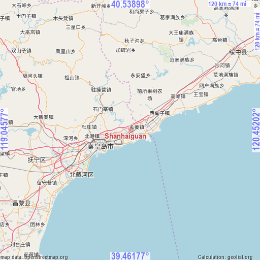
Shanhaiguan GPS coordinates[2]
40° 0' 9" North, 119° 44' 56.004" East
| Map corner | latitude | longitude |
|---|---|---|
| Upper-left | 40.53898°, | 119.04577° |
| Center: | 40.0025°, | 119.74889° |
| Lower-right: | 39.46177°, | 120.45202° |
| Map W x H: | 119.8×119.8 km | = 74.4×74.4mi |
| max Lat: | 53.31946° ⇑13.6% North |
| Shanhaiguan: | 40.0025° |
| min Lat: | ⇓86.4% South 18.22056° |
| min Long | Shanhaiguan | max Long |
| 75.07348° | 119.74889° | 134.28917° |
| W 80.2%⇐ | ⇒19.8% E |
Elevation
Elevation of Shanhaiguan is 13 m = 43 ft, and this is 471.8 m = 1548 ft below average elevation for this country.
| Max E: |
5622 m = 18445 ft | 86.9% |
| Avg. | 484.8 m = 1591 ft | |
| Shanhaiguan | 13 m = 43 ft | |
Min E: |
-3 m = -10 ft | 13.1% |
See also: Shanhaiguan elevation on elevation.city.
Geographical zone
Shanhaiguan is located in North temperate zone (between Tropic of Cancer and the Arctic Circle). Distance of this Northern Tropic circle is 1841.9 km =1144.5 mi to South.| Distance of | km | miles | from Shanhaiguan |
|---|---|---|---|
| North Pole | 5559.2 | 3454.3 | to North |
| Arctic Circle | 2953.3 | 1835.1 | to North |
| Tropic Cancer | 1841.9 | 1144.5 | to South |
| Equator | 4447.9 | 2763.8 | to South |


Nearby cities:
15 places around Shanhaiguan: (largest is in red/bold)
• Beidaihe
29.4 km =18.3 mi,  229°
229°
• Beidaihehaibin
28.1 km =17.5 mi,  224°
224°
• Dadianzi
26 km =16.2 mi,  11°
11°
• Dongshangen
41.5 km =25.8 mi,  2°
2°
• Fanjia
40.6 km =25.2 mi,  36°
36°
• Gaoling
27.2 km =16.9 mi,  54°
54°
• Guta
36.4 km =22.6 mi, 54°
• Jiabeiyan
36.4 km =22.6 mi,  357°
357°
• Lijiabao
12.8 km =8 mi,  22°
22°
• Mingshui
41.6 km =25.8 mi, 16°
• Qiansuo
19.8 km =12.3 mi,  58°
58°
• Qinhuangdao
15.8 km =9.8 mi,  240°
240°
• Wangbao
36.7 km =22.8 mi, 62°
• Wangjiazhuang
10.8 km =6.7 mi, 57°
• Xidianzi
18.6 km =11.6 mi, 59°
Sources, notices
• [Note1] Compared only with cities in China existing in our database
• [Src1] Map data: © OpenStreetMap contributors (CC-BY-SA)
• [Src2] Other city data from geonames.org with taken over terms of usage.
• [Src3] Geographical zone / Annual Mean Temperature by Robert A. Rohde @ Wikipedia
