Mingshui geodata
Mingshui (Liaoning) is a seat of a fourth-order administrative division; located in China in Asia/Shanghai (GMT+8) time zone. In our database, there are 1268 cities with bigger population. Compared to other cities in China, 87.7% of cities are located further ↓South; 81.1% of cities are located further ←West and 53.1% of cities have higher elevation than Mingshui. Note1


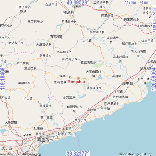
Mingshui GPS coordinates[2]
40° 21' 41.976" North, 119° 53' 16.116" East
| Map corner | latitude | longitude |
|---|---|---|
| Upper-left | 40.89529°, | 119.18469° |
| Center: | 40.36166°, | 119.88781° |
| Lower-right: | 39.82377°, | 120.59094° |
| Map W x H: | 119.1×119.1 km | = 74×74mi |
| max Lat: | 53.31946° ⇑12.3% North |
| Mingshui: | 40.36166° |
| min Lat: | ⇓87.7% South 18.22056° |
| min Long | Mingshui | max Long |
| 75.07348° | 119.88781° | 134.28917° |
| W 81.1%⇐ | ⇒18.9% E |
Elevation
Elevation of Mingshui is 143 m = 469 ft, and this is 341.8 m = 1121 ft below average elevation for this country.
| Max E: |
5622 m = 18445 ft | 53.1% |
| Avg. | 484.8 m = 1591 ft | |
| Mingshui | 143 m = 469 ft | |
Min E: |
-3 m = -10 ft | 46.9% |
See also: China elevation on elevation.city.
Geographical zone
Mingshui is located in North temperate zone (between Tropic of Cancer and the Arctic Circle). Distance of this Northern Tropic circle is 1881.9 km =1169.4 mi to South.| Distance of | km | miles | from Mingshui |
|---|---|---|---|
| North Pole | 5519.3 | 3429.5 | to North |
| Arctic Circle | 2913.4 | 1810.3 | to North |
| Tropic Cancer | 1881.9 | 1169.4 | to South |
| Equator | 4487.8 | 2788.6 | to South |


Nearby cities:
15 places around Mingshui: (largest is in red/bold)
• Dadianzi
16 km =9.9 mi,  205°
205°
• Dongshangen
9.9 km =6.2 mi,  278°
278°
• Fanjia
14.1 km =8.8 mi,  120°
120°
• Gaodianzi
21.4 km =13.3 mi,  83°
83°
• Gaoling
26.1 km =16.2 mi,  156°
156°
• Gaotai
29.3 km =18.2 mi,  86°
86°
• Guangyudian
14.4 km =8.9 mi,  32°
32°
• Guta
26.1 km =16.2 mi,  136°
136°
• Jiabeiyan
13.7 km =8.5 mi,  254°
254°
• Kuanbang
25.6 km =15.9 mi,  50°
50°
• Lijiabao
29 km =18 mi,  193°
193°
• Qiansuo
30.1 km =18.7 mi,  170°
170°
• Wangbao
31 km =19.3 mi, 138°
• Xidianzi
30.7 km =19.1 mi, 172°
• Xipingpo
25.9 km =16.1 mi,  68°
68°
Sources, notices
• [Note1] Compared only with cities in China existing in our database
• [Src1] Map data: © OpenStreetMap contributors (CC-BY-SA)
• [Src2] Other city data from geonames.org with taken over terms of usage.
• [Src3] Geographical zone / Annual Mean Temperature by Robert A. Rohde @ Wikipedia
