Daxing geodata
Daxing (Heilongjiang) is a seat of a fourth-order administrative division; located in China in Asia/Shanghai (GMT+8) time zone. In our database, there are 1268 cities with bigger population. Compared to other cities in China, 96.7% of cities are located further ↓South; 93.5% of cities are located further ←West and 52.9% of cities have higher elevation than Daxing. Note1


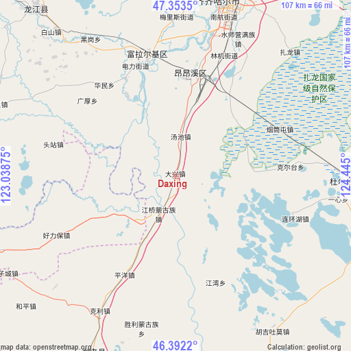
Daxing GPS coordinates[2]
46° 52' 30" North, 123° 44' 30.732" East
| Map corner | latitude | longitude |
|---|---|---|
| Upper-left | 47.3535°, | 123.03875° |
| Center: | 46.875°, | 123.74187° |
| Lower-right: | 46.3922°, | 124.445° |
| Map W x H: | 106.9×106.9 km | = 66.4×66.4mi |
| max Lat: | 53.31946° ⇑3.3% North |
| Daxing: | 46.875° |
| min Lat: | ⇓96.7% South 18.22056° |
| min Long | Daxing | max Long |
| 75.07348° | 123.74187° | 134.28917° |
| W 93.5%⇐ | ⇒6.5% E |
Elevation
Elevation of Daxing is 144 m = 472 ft, and this is 340.8 m = 1118 ft below average elevation for this country.
| Max E: |
5622 m = 18445 ft | 52.9% |
| Avg. | 484.8 m = 1591 ft | |
| Daxing | 144 m = 472 ft | |
Min E: |
-3 m = -10 ft | 47.1% |
See also: China elevation on elevation.city.
Geographical zone
Daxing is located in North temperate zone (between Tropic of Cancer and the Arctic Circle). Distance of this North polar circle is 2189.2 km =1360.3 mi to North.| Distance of | km | miles | from Daxing |
|---|---|---|---|
| North Pole | 4795.1 | 2979.5 | to North |
| Arctic Circle | 2189.2 | 1360.3 | to North |
| Tropic Cancer | 2606.1 | 1619.4 | to South |
| Equator | 5212 | 3238.6 | to South |


Nearby cities:
15 places around Daxing: (largest is in red/bold)
• Du’ermenqin
33 km =20.5 mi,  332°
332°
• Guanghou
35.3 km =21.9 mi,  310°
310°
• Hong’an
37.8 km =23.5 mi,  346°
346°
• Huamin
35.2 km =21.9 mi,  321°
321°
• Hulan Ergi
37.5 km =23.3 mi, 347°
• Jiangqiao
12.8 km =8 mi,  203°
203°
• Jiangwan
34.8 km =21.6 mi,  159°
159°
• Kertai
35.1 km =21.8 mi,  86°
86°
• Nuwen Muren
17.4 km =10.8 mi,  217°
217°
• Pingyang
34.1 km =21.2 mi,  206°
206°
• Tangchi
11.9 km =7.4 mi,  8°
8°
• Touzhan
38.3 km =23.8 mi,  284°
284°
• Xinxing
31.5 km =19.6 mi, 9°
• Yantongtun
35.5 km =22.1 mi,  65°
65°
• Yushutun
33 km =20.5 mi,  19°
19°
Sources, notices
• [Note1] Compared only with cities in China existing in our database
• [Src1] Map data: © OpenStreetMap contributors (CC-BY-SA)
• [Src2] Other city data from geonames.org with taken over terms of usage.
• [Src3] Geographical zone / Annual Mean Temperature by Robert A. Rohde @ Wikipedia
