Kertai geodata
Kertai (Heilongjiang) is a seat of a fourth-order administrative division; located in China in Asia/Shanghai (GMT+8) time zone. In our database, there are 1268 cities with bigger population. Compared to other cities in China, 96.8% of cities are located further ↓South; 94% of cities are located further ←West and 52.7% of cities have higher elevation than Kertai. Note1


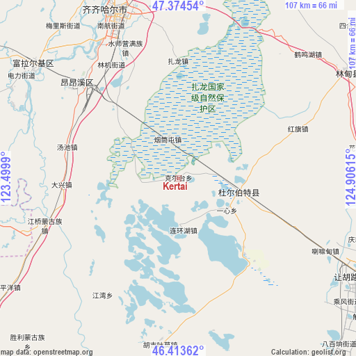
Kertai GPS coordinates[2]
46° 53' 46.428" North, 124° 12' 10.872" East
| Map corner | latitude | longitude |
|---|---|---|
| Upper-left | 47.37454°, | 123.4999° |
| Center: | 46.89623°, | 124.20302° |
| Lower-right: | 46.41362°, | 124.90615° |
| Map W x H: | 106.8×106.8 km | = 66.4×66.4mi |
| max Lat: | 53.31946° ⇑3.2% North |
| Kertai: | 46.89623° |
| min Lat: | ⇓96.8% South 18.22056° |
| min Long | Kertai | max Long |
| 75.07348° | 124.20302° | 134.28917° |
| W 94%⇐ | ⇒6% E |
Elevation
Elevation of Kertai is 145 m = 476 ft, and this is 339.8 m = 1115 ft below average elevation for this country.
| Max E: |
5622 m = 18445 ft | 52.7% |
| Avg. | 484.8 m = 1591 ft | |
| Kertai | 145 m = 476 ft | |
Min E: |
-3 m = -10 ft | 47.3% |
See also: China elevation on elevation.city.
Geographical zone
Kertai is located in North temperate zone (between Tropic of Cancer and the Arctic Circle). Distance of this North polar circle is 2186.8 km =1358.8 mi to North.| Distance of | km | miles | from Kertai |
|---|---|---|---|
| North Pole | 4792.7 | 2978 | to North |
| Arctic Circle | 2186.8 | 1358.8 | to North |
| Tropic Cancer | 2608.5 | 1620.8 | to South |
| Equator | 5214.4 | 3240.1 | to South |


Nearby cities:
15 places around Kertai: (largest is in red/bold)
• Baiyinnuole
15.3 km =9.5 mi,  174°
174°
• Damin
47 km =29.2 mi,  331°
331°
• Daxing
35.1 km =21.8 mi,  266°
266°
• Hongqi
38.7 km =24 mi,  67°
67°
• Jiangqiao
42.6 km =26.5 mi,  250°
250°
• Jiangwan
41.7 km =25.9 mi,  213°
213°
• Nuwen Muren
48.6 km =30.2 mi, 250°
• Shuishiying
42.3 km =26.3 mi,  337°
337°
• Taikang
18.6 km =11.6 mi,  102°
102°
• Tangchi
34.6 km =21.5 mi,  285°
285°
• Xinxing
41.4 km =25.7 mi,  313°
313°
• Yantongtun
12.7 km =7.9 mi,  347°
347°
• Yixin
17.3 km =10.7 mi,  123°
123°
• Yushutun
37.4 km =23.2 mi,  320°
320°
• Zhalong
35.1 km =21.8 mi,  359°
359°
Sources, notices
• [Note1] Compared only with cities in China existing in our database
• [Src1] Map data: © OpenStreetMap contributors (CC-BY-SA)
• [Src2] Other city data from geonames.org with taken over terms of usage.
• [Src3] Geographical zone / Annual Mean Temperature by Robert A. Rohde @ Wikipedia
