Yushutun geodata
Yushutun (Heilongjiang) is a seat of a fourth-order administrative division; located in China in Asia/Shanghai (GMT+8) time zone. In our database, there are 1268 cities with bigger population. Compared to other cities in China, 97.2% of cities are located further ↓South; 93.7% of cities are located further ←West and 52.4% of cities have higher elevation than Yushutun. Note1


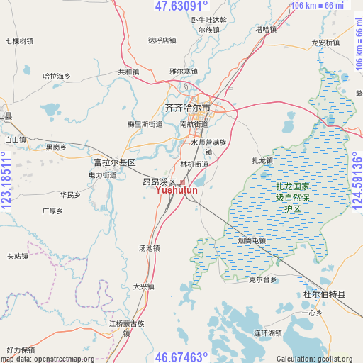
Yushutun GPS coordinates[2]
47° 9' 17.712" North, 123° 53' 17.628" East
| Map corner | latitude | longitude |
|---|---|---|
| Upper-left | 47.63091°, | 123.18511° |
| Center: | 47.15492°, | 123.88823° |
| Lower-right: | 46.67463°, | 124.59136° |
| Map W x H: | 106.3×106.3 km | = 66.1×66.1mi |
| max Lat: | 53.31946° ⇑2.8% North |
| Yushutun: | 47.15492° |
| min Lat: | ⇓97.2% South 18.22056° |
| min Long | Yushutun | max Long |
| 75.07348° | 123.88823° | 134.28917° |
| W 93.7%⇐ | ⇒6.3% E |
Elevation
Elevation of Yushutun is 147 m = 482 ft, and this is 337.8 m = 1108 ft below average elevation for this country.
| Max E: |
5622 m = 18445 ft | 52.4% |
| Avg. | 484.8 m = 1591 ft | |
| Yushutun | 147 m = 482 ft | |
Min E: |
-3 m = -10 ft | 47.6% |
See also: China elevation on elevation.city.
Geographical zone
Yushutun is located in North temperate zone (between Tropic of Cancer and the Arctic Circle). Distance of this North polar circle is 2158 km =1340.9 mi to North.| Distance of | km | miles | from Yushutun |
|---|---|---|---|
| North Pole | 4763.9 | 2960.1 | to North |
| Arctic Circle | 2158 | 1340.9 | to North |
| Tropic Cancer | 2637.2 | 1638.7 | to South |
| Equator | 5243.1 | 3257.9 | to South |


Nearby cities:
15 places around Yushutun: (largest is in red/bold)
• Bukui
22.8 km =14.2 mi,  12°
12°
• Changqing
22.8 km =14.2 mi,  288°
288°
• Damin
12.4 km =7.7 mi, 5°
• Du’ermenqin
26.3 km =16.3 mi,  266°
266°
• Hali
26.1 km =16.2 mi,  317°
317°
• Hong’an
20.7 km =12.9 mi, 285°
• Hulan Ergi
20 km =12.4 mi, 285°
• Longhua
21.5 km =13.4 mi,  18°
18°
• Meilisi
20.5 km =12.7 mi,  330°
330°
• Nanhang
18.3 km =11.4 mi, 14°
• Qiqihar
21.4 km =13.3 mi, 14°
• Shuishiying
12.9 km =8 mi,  36°
36°
• Tangchi
21.5 km =13.4 mi,  205°
205°
• Xinxing
5.9 km =3.7 mi, 269°
• Zhalong
24.5 km =15.2 mi,  74°
74°
Sources, notices
• [Note1] Compared only with cities in China existing in our database
• [Src1] Map data: © OpenStreetMap contributors (CC-BY-SA)
• [Src2] Other city data from geonames.org with taken over terms of usage.
• [Src3] Geographical zone / Annual Mean Temperature by Robert A. Rohde @ Wikipedia
