Chaihe geodata
Chaihe (Heilongjiang) is a seat of a fourth-order administrative division; located in China in Asia/Shanghai (GMT+8) time zone. With population of 67,963 people, there are 629 cities with bigger population in this country. Compared to other cities in China, 93.7% of cities are located further ↓South; 98.9% of cities are located further ←West and 57.4% of cities have lower elevation than Chaihe. Note1


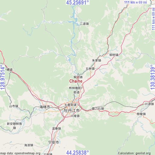
Chaihe GPS coordinates[2]
44° 45' 35.28" North, 129° 40' 41.736" East
| Map corner | latitude | longitude |
|---|---|---|
| Upper-left | 45.25691°, | 128.97514° |
| Center: | 44.7598°, | 129.67826° |
| Lower-right: | 44.25838°, | 130.38139° |
| Map W x H: | 111×111 km | = 69×69mi |
| max Lat: | 53.31946° ⇑6.3% North |
| Chaihe: | 44.7598° |
| min Lat: | ⇓93.7% South 18.22056° |
| min Long | Chaihe | max Long |
| 75.07348° | 129.67826° | 134.28917° |
| W 98.9%⇐ | ⇒1.1% E |
Elevation
Elevation of Chaihe is 229 m = 751 ft, and this is 255.8 m = 839 ft below average elevation for this country.
| Max E: |
5622 m = 18445 ft | 42.6% |
| Avg. | 484.8 m = 1591 ft | |
| Chaihe | 229 m = 751 ft | |
Min E: |
-3 m = -10 ft | 57.4% |
See also: Chaihe elevation on elevation.city.
Geographical zone
Chaihe is located in North temperate zone (between Tropic of Cancer and the Arctic Circle). Distance of this Northern Tropic circle is 2370.9 km =1473.2 mi to South.| Distance of | km | miles | from Chaihe |
|---|---|---|---|
| North Pole | 5030.2 | 3125.6 | to North |
| Arctic Circle | 2424.4 | 1506.5 | to North |
| Tropic Cancer | 2370.9 | 1473.2 | to South |
| Equator | 4976.8 | 3092.4 | to South |


Nearby cities:
15 places around Chaihe: (largest is in red/bold)
• Bei’an
16.8 km =10.4 mi,  208°
208°
• Hainan
26.4 km =16.4 mi, 214°
• Hualin
8.6 km =5.3 mi,  181°
181°
• Liushu
30.8 km =19.1 mi,  57°
57°
• Modaoshi
26.4 km =16.4 mi,  147°
147°
• Mudanjiang
20.6 km =12.8 mi,  197°
197°
• Tieling
18.7 km =11.6 mi, 180°
• Wulin
11.1 km =6.9 mi,  53°
53°
• Xianfeng
21.4 km =13.3 mi, 196°
• Xiangyang
20.6 km =12.8 mi, 202°
• Xinglong
25.1 km =15.6 mi,  193°
193°
• Xin’an
20.4 km =12.7 mi, 191°
• Yangming
18.7 km =11.6 mi, 194°
• Yanjiang
22.9 km =14.2 mi, 200°
• Zhujia
18.2 km =11.3 mi, 47°
Sources, notices
• [Note1] Compared only with cities in China existing in our database
• [Src1] Map data: © OpenStreetMap contributors (CC-BY-SA)
• [Src2] Other city data from geonames.org with taken over terms of usage.
• [Src3] Geographical zone / Annual Mean Temperature by Robert A. Rohde @ Wikipedia
