Liushu geodata
Liushu (Heilongjiang) is a seat of a fourth-order administrative division; located in China in Asia/Shanghai (GMT+8) time zone. In our database, there are 1268 cities with bigger population. Compared to other cities in China, 93.8% of cities are located further ↓South; 99.1% of cities are located further ←West and 64% of cities have lower elevation than Liushu. Note1


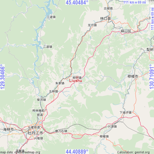
Liushu GPS coordinates[2]
44° 54' 32.472" North, 130° 0' 28.008" East
| Map corner | latitude | longitude |
|---|---|---|
| Upper-left | 45.40484°, | 129.30466° |
| Center: | 44.90902°, | 130.00778° |
| Lower-right: | 44.40889°, | 130.71091° |
| Map W x H: | 110.7×110.7 km | = 68.8×68.8mi |
| max Lat: | 53.31946° ⇑6.2% North |
| Liushu: | 44.90902° |
| min Lat: | ⇓93.8% South 18.22056° |
| min Long | Liushu | max Long |
| 75.07348° | 130.00778° | 134.28917° |
| W 99.1%⇐ | ⇒0.90000000000001% E |
Elevation
Elevation of Liushu is 310 m = 1017 ft, and this is 174.8 m = 573 ft below average elevation for this country.
| Max E: |
5622 m = 18445 ft | 36% |
| Avg. | 484.8 m = 1591 ft | |
| Liushu | 310 m = 1017 ft | |
Min E: |
-3 m = -10 ft | 64% |
See also: China elevation on elevation.city.
Geographical zone
Liushu is located in North temperate zone (between Tropic of Cancer and the Arctic Circle). Distance of this Northern Tropic circle is 2387.5 km =1483.5 mi to South.| Distance of | km | miles | from Liushu |
|---|---|---|---|
| North Pole | 5013.6 | 3115.3 | to North |
| Arctic Circle | 2407.8 | 1496.1 | to North |
| Tropic Cancer | 2387.5 | 1483.5 | to South |
| Equator | 4993.4 | 3102.8 | to South |


Nearby cities:
15 places around Liushu: (largest is in red/bold)
• Bamiantong
40.3 km =25 mi,  88°
88°
• Bei’an
46.3 km =28.8 mi,  227°
227°
• Chaihe
30.8 km =19.1 mi,  237°
237°
• Erdaohezi
30.6 km =19 mi,  316°
316°
• Fulu
45.3 km =28.1 mi, 86°
• Hexi
37.5 km =23.3 mi, 86°
• Hualin
36.3 km =22.6 mi, 226°
• Longzhua
39.3 km =24.4 mi,  15°
15°
• Modaoshi
40.5 km =25.2 mi,  196°
196°
• Tieling
43.9 km =27.3 mi,  216°
216°
• Wulin
19.7 km =12.2 mi, 239°
• Xiachengzi
42.9 km =26.7 mi,  125°
125°
• Xingyuan
43.3 km =26.9 mi,  144°
144°
• Yangming
46.3 km =28.8 mi, 221°
• Zhujia
13.3 km =8.3 mi,  251°
251°
Sources, notices
• [Note1] Compared only with cities in China existing in our database
• [Src1] Map data: © OpenStreetMap contributors (CC-BY-SA)
• [Src2] Other city data from geonames.org with taken over terms of usage.
• [Src3] Geographical zone / Annual Mean Temperature by Robert A. Rohde @ Wikipedia
