Bayangang geodata
Bayangang (Heilongjiang) is a seat of a fourth-order administrative division; located in China in Asia/Shanghai (GMT+8) time zone. In our database, there are 1268 cities with bigger population. Compared to other cities in China, 95% of cities are located further ↓South; 97.6% of cities are located further ←West and 57.7% of cities have higher elevation than Bayangang. Note1


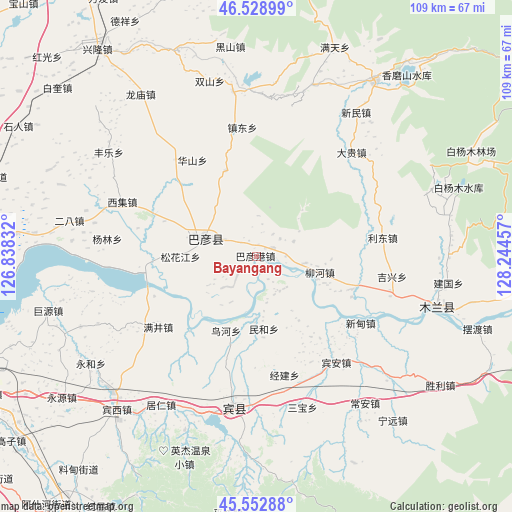
Bayangang GPS coordinates[2]
46° 2' 35.124" North, 127° 32' 29.184" East
| Map corner | latitude | longitude |
|---|---|---|
| Upper-left | 46.52899°, | 126.83832° |
| Center: | 46.04309°, | 127.54144° |
| Lower-right: | 45.55288°, | 128.24457° |
| Map W x H: | 108.5×108.5 km | = 67.4×67.4mi |
| max Lat: | 53.31946° ⇑5% North |
| Bayangang: | 46.04309° |
| min Lat: | ⇓95% South 18.22056° |
| min Long | Bayangang | max Long |
| 75.07348° | 127.54144° | 134.28917° |
| W 97.6%⇐ | ⇒2.4% E |
Elevation
Elevation of Bayangang is 113 m = 371 ft, and this is 371.8 m = 1220 ft below average elevation for this country.
| Max E: |
5622 m = 18445 ft | 57.7% |
| Avg. | 484.8 m = 1591 ft | |
| Bayangang | 113 m = 371 ft | |
Min E: |
-3 m = -10 ft | 42.3% |
See also: China elevation on elevation.city.
Geographical zone
Bayangang is located in North temperate zone (between Tropic of Cancer and the Arctic Circle). Distance of this North polar circle is 2281.7 km =1417.8 mi to North.| Distance of | km | miles | from Bayangang |
|---|---|---|---|
| North Pole | 4887.6 | 3037 | to North |
| Arctic Circle | 2281.7 | 1417.8 | to North |
| Tropic Cancer | 2513.6 | 1561.9 | to South |
| Equator | 5119.5 | 3181.1 | to South |


Nearby cities:
15 places around Bayangang: (largest is in red/bold)
• Bayan
11.6 km =7.2 mi,  288°
288°
• Bin’an
28.1 km =17.5 mi,  142°
142°
• Fujiang
6.7 km =4.2 mi,  259°
259°
• Huashan
24.5 km =15.2 mi,  326°
326°
• Jingjian
25.9 km =16.1 mi,  166°
166°
• Jixing
28.9 km =18 mi,  98°
98°
• Lidong
27.3 km =17 mi,  81°
81°
• Liuhe
14.1 km =8.8 mi, 104°
• Longquan
19.4 km =12.1 mi,  340°
340°
• Manjing
25.6 km =15.9 mi,  234°
234°
• Minhe
15.3 km =9.5 mi, 174°
• Niaohe
16.9 km =10.5 mi,  202°
202°
• Songhuajiang
16.7 km =10.4 mi,  267°
267°
• Xindian
26 km =16.2 mi,  122°
122°
• Zhendong
27.6 km =17.1 mi,  354°
354°
Sources, notices
• [Note1] Compared only with cities in China existing in our database
• [Src1] Map data: © OpenStreetMap contributors (CC-BY-SA)
• [Src2] Other city data from geonames.org with taken over terms of usage.
• [Src3] Geographical zone / Annual Mean Temperature by Robert A. Rohde @ Wikipedia
