Bayan geodata
Bayan (Heilongjiang) is a seat of a third-order administrative division; located in China in Asia/Shanghai (GMT+8) time zone. With population of 55,186 people, there are 790 cities with bigger population in this country. Compared to other cities in China, 95.1% of cities are located further ↓South; 97.4% of cities are located further ←West and 54.4% of cities have higher elevation than Bayan. Note1


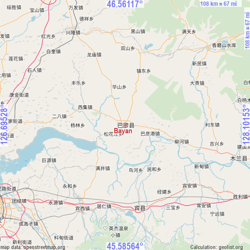
Bayan GPS coordinates[2]
46° 4' 32.016" North, 127° 23' 54.24" East
| Map corner | latitude | longitude |
|---|---|---|
| Upper-left | 46.56117°, | 126.69528° |
| Center: | 46.07556°, | 127.3984° |
| Lower-right: | 45.58564°, | 128.10153° |
| Map W x H: | 108.5×108.5 km | = 67.4×67.4mi |
| max Lat: | 53.31946° ⇑4.9% North |
| Bayan: | 46.07556° |
| min Lat: | ⇓95.1% South 18.22056° |
| min Long | Bayan | max Long |
| 75.07348° | 127.3984° | 134.28917° |
| W 97.4%⇐ | ⇒2.6% E |
Elevation
Elevation of Bayan is 135 m = 443 ft, and this is 349.8 m = 1148 ft below average elevation for this country.
| Max E: |
5622 m = 18445 ft | 54.4% |
| Avg. | 484.8 m = 1591 ft | |
| Bayan | 135 m = 443 ft | |
Min E: |
-3 m = -10 ft | 45.6% |
See also: Bayan elevation on elevation.city.
Geographical zone
Bayan is located in North temperate zone (between Tropic of Cancer and the Arctic Circle). Distance of this North polar circle is 2278.1 km =1415.5 mi to North.| Distance of | km | miles | from Bayan |
|---|---|---|---|
| North Pole | 4883.9 | 3034.7 | to North |
| Arctic Circle | 2278.1 | 1415.5 | to North |
| Tropic Cancer | 2517.2 | 1564.1 | to South |
| Equator | 5123.1 | 3183.3 | to South |


Nearby cities:
15 places around Bayan: (largest is in red/bold)
• Bayangang
11.6 km =7.2 mi,  108°
108°
• Erba
28.7 km =17.8 mi,  278°
278°
• Fengle
27.3 km =17 mi,  312°
312°
• Fujiang
6.5 km =4 mi,  136°
136°
• Huashan
17 km =10.6 mi,  351°
351°
• Liuhe
25.7 km =16 mi, 106°
• Longquan
15.4 km =9.6 mi,  17°
17°
• Manjing
20.9 km =13 mi,  207°
207°
• Minhe
22.7 km =14.1 mi,  146°
146°
• Niaohe
19.8 km =12.3 mi,  166°
166°
• Songhuajiang
7.1 km =4.4 mi,  232°
232°
• Waxing
31.9 km =19.8 mi,  11°
11°
• Xiji
19.3 km =12 mi,  294°
294°
• Yanglin
20.6 km =12.8 mi,  270°
270°
• Zhendong
25.2 km =15.7 mi, 18°
Sources, notices
• [Note1] Compared only with cities in China existing in our database
• [Src1] Map data: © OpenStreetMap contributors (CC-BY-SA)
• [Src2] Other city data from geonames.org with taken over terms of usage.
• [Src3] Geographical zone / Annual Mean Temperature by Robert A. Rohde @ Wikipedia
