Songjiao geodata
Songjiao (Jilin) is a seat of a fourth-order administrative division; located in China in Asia/Shanghai (GMT+8) time zone. In our database, there are 1268 cities with bigger population. Compared to other cities in China, 91.2% of cities are located further ↓South; 97.2% of cities are located further ←West and 72.2% of cities have lower elevation than Songjiao. Note1


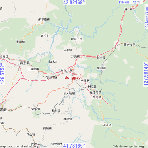
Songjiao GPS coordinates[2]
42° 18' 13.752" North, 127° 16' 41.952" East
| Map corner | latitude | longitude |
|---|---|---|
| Upper-left | 42.82169°, | 126.5752° |
| Center: | 42.30382°, | 127.27832° |
| Lower-right: | 41.78165°, | 127.98145° |
| Map W x H: | 115.6×115.6 km | = 71.8×71.8mi |
| max Lat: | 53.31946° ⇑8.8% North |
| Songjiao: | 42.30382° |
| min Lat: | ⇓91.2% South 18.22056° |
| min Long | Songjiao | max Long |
| 75.07348° | 127.27832° | 134.28917° |
| W 97.2%⇐ | ⇒2.8% E |
Elevation
Elevation of Songjiao is 459 m = 1506 ft, and this is 25.8 m = 85 ft below average elevation for this country.
| Max E: |
5622 m = 18445 ft | 27.8% |
| Avg. | 484.8 m = 1591 ft | |
| Songjiao | 459 m = 1506 ft | |
Min E: |
-3 m = -10 ft | 72.2% |
See also: China elevation on elevation.city.
Geographical zone
Songjiao is located in North temperate zone (between Tropic of Cancer and the Arctic Circle). Distance of this Northern Tropic circle is 2097.8 km =1303.5 mi to South.| Distance of | km | miles | from Songjiao |
|---|---|---|---|
| North Pole | 5303.3 | 3295.3 | to North |
| Arctic Circle | 2697.4 | 1676.1 | to North |
| Tropic Cancer | 2097.8 | 1303.5 | to South |
| Equator | 4703.7 | 2922.7 | to South |


Nearby cities:
15 places around Songjiao: (largest is in red/bold)
• Beigang
24.7 km =15.3 mi,  58°
58°
• Choushui
19.4 km =12.1 mi,  301°
301°
• Donggang
23.3 km =14.5 mi,  132°
132°
• Fusong
2.4 km =1.5 mi,  348°
348°
• Huayuankou
17.8 km =11.1 mi,  263°
263°
• Quanyang
22.6 km =14 mi,  76°
76°
• Songjiang
10.8 km =6.7 mi,  143°
143°
• Songjianghe
21.1 km =13.1 mi, 128°
• Wanliang
14.3 km =8.9 mi,  3°
3°
• Xianrenqiao
15.2 km =9.4 mi,  194°
194°
• Xingcan
19.9 km =12.4 mi, 346°
• Xinglong
10 km =6.2 mi,  117°
117°
• Xinxigang
27.3 km =17 mi,  166°
166°
• Yushu
27.7 km =17.2 mi,  340°
340°
• Yushuchuan
6.8 km =4.2 mi,  294°
294°
Sources, notices
• [Note1] Compared only with cities in China existing in our database
• [Src1] Map data: © OpenStreetMap contributors (CC-BY-SA)
• [Src2] Other city data from geonames.org with taken over terms of usage.
• [Src3] Geographical zone / Annual Mean Temperature by Robert A. Rohde @ Wikipedia
