Guangyudian geodata
Guangyudian (Liaoning) is a seat of a fourth-order administrative division; located in China in Asia/Shanghai (GMT+8) time zone. In our database, there are 1268 cities with bigger population. Compared to other cities in China, 88% of cities are located further ↓South; 81.8% of cities are located further ←West and 58.9% of cities have higher elevation than Guangyudian. Note1


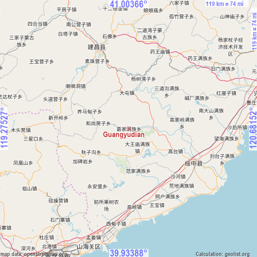
Guangyudian GPS coordinates[2]
40° 28' 15.24" North, 119° 58' 42.204" East
| Map corner | latitude | longitude |
|---|---|---|
| Upper-left | 41.00366°, | 119.27527° |
| Center: | 40.4709°, | 119.97839° |
| Lower-right: | 39.93388°, | 120.68152° |
| Map W x H: | 118.9×118.9 km | = 73.9×73.9mi |
| max Lat: | 53.31946° ⇑12% North |
| Guangyudian: | 40.4709° |
| min Lat: | ⇓88% South 18.22056° |
| min Long | Guangyudian | max Long |
| 75.07348° | 119.97839° | 134.28917° |
| W 81.8%⇐ | ⇒18.2% E |
Elevation
Elevation of Guangyudian is 105 m = 344 ft, and this is 379.8 m = 1246 ft below average elevation for this country.
| Max E: |
5622 m = 18445 ft | 58.9% |
| Avg. | 484.8 m = 1591 ft | |
| Guangyudian | 105 m = 344 ft | |
Min E: |
-3 m = -10 ft | 41.1% |
See also: China elevation on elevation.city.
Geographical zone
Guangyudian is located in North temperate zone (between Tropic of Cancer and the Arctic Circle). Distance of this Northern Tropic circle is 1894 km =1176.9 mi to South.| Distance of | km | miles | from Guangyudian |
|---|---|---|---|
| North Pole | 5507.1 | 3422 | to North |
| Arctic Circle | 2901.2 | 1802.7 | to North |
| Tropic Cancer | 1894 | 1176.9 | to South |
| Equator | 4499.9 | 2796.1 | to South |


Nearby cities:
15 places around Guangyudian: (largest is in red/bold)
• Chengjiao
34.2 km =21.3 mi,  116°
116°
• Dadianzi
30.3 km =18.8 mi,  208°
208°
• Dongshangen
20.4 km =12.7 mi,  238°
238°
• Fanjia
19.8 km =12.3 mi,  166°
166°
• Gaodianzi
16.7 km =10.4 mi,  125°
125°
• Gaotai
23.9 km =14.9 mi, 115°
• Guta
32.8 km =20.4 mi,  161°
161°
• Huangdi
35.8 km =22.2 mi,  137°
137°
• Jiabeiyan
26.1 km =16.2 mi,  233°
233°
• Kuanbang
12.8 km =8 mi,  71°
71°
• Mingshui
14.4 km =8.9 mi, 212°
• Shahe
31.5 km =19.6 mi, 133°
• Suizhong
34.2 km =21.3 mi, 117°
• Xipingpo
16.5 km =10.3 mi,  98°
98°
• 城郊
34.2 km =21.3 mi, 116°
Sources, notices
• [Note1] Compared only with cities in China existing in our database
• [Src1] Map data: © OpenStreetMap contributors (CC-BY-SA)
• [Src2] Other city data from geonames.org with taken over terms of usage.
• [Src3] Geographical zone / Annual Mean Temperature by Robert A. Rohde @ Wikipedia
