Jingzhu geodata
Jingzhu (Hunan) is a seat of a fourth-order administrative division; located in China in Asia/Shanghai (GMT+8) time zone. In our database, there are 1268 cities with bigger population. Compared to other cities in China, 85.8% of cities are located further ↑North; 62.8% of cities are located further →East and 85.2% of cities have lower elevation than Jingzhu. Note1


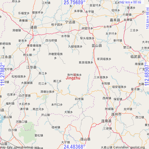
Jingzhu GPS coordinates[2]
25° 7' 18.984" North, 111° 58' 54.984" East
| Map corner | latitude | longitude |
|---|---|---|
| Upper-left | 25.75689°, | 111.27882° |
| Center: | 25.12194°, | 111.98194° |
| Lower-right: | 24.48368°, | 112.68507° |
| Map W x H: | 141.6×141.6 km | = 88×88mi |
| max Lat: | 53.31946° ⇑85.8% North |
| Jingzhu: | 25.12194° |
| min Lat: | ⇓14.2% South 18.22056° |
| min Long | Jingzhu | max Long |
| 75.07348° | 111.98194° | 134.28917° |
| W 37.2%⇐ | ⇒62.8% E |
Elevation
Elevation of Jingzhu is 997 m = 3271 ft, and this is 512.2 m = 1680 ft above average elevation for this country.
| Max E: |
5622 m = 18445 ft | 14.8% |
| Jingzhu | 997 m 3271 ft | |
| Avg. | 484.8 m = 1591 ft | |
Min E: |
-3 m = -10 ft | 85.2% |
See also: China elevation on elevation.city.
Geographical zone
Jingzhu is located in North temperate zone (between Tropic of Cancer and the Arctic Circle). Distance of this Northern Tropic circle is 187.4 km =116.4 mi to South.| Distance of | km | miles | from Jingzhu |
|---|---|---|---|
| North Pole | 7213.8 | 4482.4 | to North |
| Arctic Circle | 4607.9 | 2863.2 | to North |
| Tropic Cancer | 187.4 | 116.4 | to South |
| Equator | 2793.3 | 1735.7 | to South |


Nearby cities:
15 places around Jingzhu: (largest is in red/bold)
• Daqiao
12.8 km =8 mi,  93°
93°
• Dongbei
34.8 km =21.6 mi,  114°
114°
• Dongtian
33.6 km =20.9 mi,  275°
275°
• Fengyang
30.4 km =18.9 mi, 105°
• Hengling
34.8 km =21.6 mi,  313°
313°
• Huiyuan
30.7 km =19.1 mi,  21°
21°
• Jiangdong
31.9 km =19.8 mi,  61°
61°
• Jiuyi
27 km =16.8 mi,  1°
1°
• Litou
36.8 km =22.9 mi, 19°
• Sanshui
25.2 km =15.7 mi,  95°
95°
• Suocheng
23 km =14.3 mi,  45°
45°
• Tafeng
33.2 km =20.6 mi,  39°
39°
• Xiangjiang
17.4 km =10.8 mi,  250°
250°
• Xi’an
38.1 km =23.7 mi,  125°
125°
• Ziliang
16.1 km =10 mi, 42°
Sources, notices
• [Note1] Compared only with cities in China existing in our database
• [Src1] Map data: © OpenStreetMap contributors (CC-BY-SA)
• [Src2] Other city data from geonames.org with taken over terms of usage.
• [Src3] Geographical zone / Annual Mean Temperature by Robert A. Rohde @ Wikipedia
