Dongbei geodata
Dongbei (Guangdong) is a seat of a fourth-order administrative division; located in China in Asia/Shanghai (GMT+8) time zone. In our database, there are 1268 cities with bigger population. Compared to other cities in China, 86.4% of cities are located further ↑North; 61.2% of cities are located further →East and 52.1% of cities have higher elevation than Dongbei. Note1


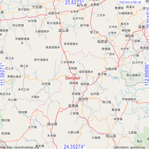
Dongbei GPS coordinates[2]
24° 59' 30.012" North, 112° 17' 44.988" East
| Map corner | latitude | longitude |
|---|---|---|
| Upper-left | 25.6273°, | 111.59271° |
| Center: | 24.99167°, | 112.29583° |
| Lower-right: | 24.35274°, | 112.99896° |
| Map W x H: | 141.7×141.7 km | = 88×88mi |
| max Lat: | 53.31946° ⇑86.4% North |
| Dongbei: | 24.99167° |
| min Lat: | ⇓13.6% South 18.22056° |
| min Long | Dongbei | max Long |
| 75.07348° | 112.29583° | 134.28917° |
| W 38.8%⇐ | ⇒61.2% E |
Elevation
Elevation of Dongbei is 149 m = 489 ft, and this is 335.8 m = 1102 ft below average elevation for this country.
| Max E: |
5622 m = 18445 ft | 52.1% |
| Avg. | 484.8 m = 1591 ft | |
| Dongbei | 149 m = 489 ft | |
Min E: |
-3 m = -10 ft | 47.9% |
See also: China elevation on elevation.city.
Geographical zone
Dongbei is located in North temperate zone (between Tropic of Cancer and the Arctic Circle). Distance of this Northern Tropic circle is 172.9 km =107.4 mi to South.| Distance of | km | miles | from Dongbei |
|---|---|---|---|
| North Pole | 7228.2 | 4491.4 | to North |
| Arctic Circle | 4622.4 | 2872.2 | to North |
| Tropic Cancer | 172.9 | 107.4 | to South |
| Equator | 2778.8 | 1726.7 | to South |


Nearby cities:
15 places around Dongbei: (largest is in red/bold)
• Bao’an
12.3 km =7.6 mi,  132°
132°
• Dalubian
32.9 km =20.4 mi,  82°
82°
• Daqiao
23.2 km =14.4 mi,  305°
305°
• Fengyang
6.8 km =4.2 mi,  340°
340°
• Hedong
33.6 km =20.9 mi,  220°
220°
• Jiangdong
29.8 km =18.5 mi,  353°
353°
• Lianzhou
24.5 km =15.2 mi,  161°
161°
• Longping
26.4 km =16.4 mi,  136°
136°
• Sanjiang
30.1 km =18.7 mi,  180°
180°
• Sanshui
13.9 km =8.6 mi,  332°
332°
• Shantang
31.9 km =19.8 mi,  73°
73°
• Xingzi
25.6 km =15.9 mi,  87°
87°
• Xi’an
7.9 km =4.9 mi,  185°
185°
• Yao’an
11.3 km =7 mi, 74°
• Ziliang
33.5 km =20.8 mi,  321°
321°
Sources, notices
• [Note1] Compared only with cities in China existing in our database
• [Src1] Map data: © OpenStreetMap contributors (CC-BY-SA)
• [Src2] Other city data from geonames.org with taken over terms of usage.
• [Src3] Geographical zone / Annual Mean Temperature by Robert A. Rohde @ Wikipedia
