Buzhai geodata
Buzhai (Guangdong) is a seat of a fourth-order administrative division; located in China in Asia/Shanghai (GMT+8) time zone. In our database, there are 1268 cities with bigger population. Compared to other cities in China, 91.5% of cities are located further ↑North; 60.9% of cities are located further ←West and 72.3% of cities have higher elevation than Buzhai. Note1


Buzhai GPS coordinates[2]
23° 38' 59.568" North, 116° 9' 7.128" East
| Map corner | latitude | longitude |
|---|---|---|
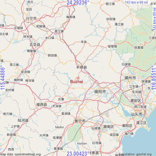
| Upper-left | 24.29236°, | 115.44886° |
| Center: | 23.64988°, | 116.15198° |
| Lower-right: | 23.00423°, | 116.85511° |
| Map W x H: | 143.2×143.2 km | = 89×89mi |
| max Lat: | 53.31946° ⇑91.5% North |
| Buzhai: | 23.64988° |
| min Lat: | ⇓8.5% South 18.22056° |
| min Long | Buzhai | max Long |
| 75.07348° | 116.15198° | 134.28917° |
| W 60.9%⇐ | ⇒39.1% E |
Elevation
Elevation of Buzhai is 44 m = 144 ft, and this is 440.8 m = 1446 ft below average elevation for this country.
| Max E: |
5622 m = 18445 ft | 72.3% |
| Avg. | 484.8 m = 1591 ft | |
| Buzhai | 44 m = 144 ft | |
Min E: |
-3 m = -10 ft | 27.7% |
See also: China elevation on elevation.city.
Geographical zone
Buzhai is located in North temperate zone (between Tropic of Cancer and the Arctic Circle). Distance of this Northern Tropic circle is 23.7 km =14.7 mi to South.| Distance of | km | miles | from Buzhai |
|---|---|---|---|
| North Pole | 7377.4 | 4584.1 | to North |
| Arctic Circle | 4771.6 | 2964.9 | to North |
| Tropic Cancer | 23.7 | 14.7 | to South |
| Equator | 2629.6 | 1634 | to South |


Nearby cities:
15 places around Buzhai: (largest is in red/bold)
• Baita
11.2 km =7 mi,  152°
152°
• Dongyuan
15.5 km =9.6 mi,  188°
188°
• Guiling
11.1 km =6.9 mi,  128°
128°
• Jingxiyuan
16.7 km =10.4 mi,  215°
215°
• Linpan
13.7 km =8.5 mi,  140°
140°
• Longwei
8.3 km =5.2 mi,  183°
183°
• Nanxi
18.3 km =11.4 mi, 150°
• Tangkeng
12.3 km =7.6 mi,  9°
9°
• Tangnan
9.6 km =6 mi,  31°
31°
• Tangxi
12 km =7.5 mi,  0°
0°
• Wujingfu
12.5 km =7.8 mi, 222°
• Xichang
18.2 km =11.3 mi,  103°
103°
• Xinheng
13.8 km =8.6 mi,  94°
94°
• Yuecheng
15.3 km =9.5 mi, 128°
• Yuhu
9 km =5.6 mi,  66°
66°
Sources, notices
• [Note1] Compared only with cities in China existing in our database
• [Src1] Map data: © OpenStreetMap contributors (CC-BY-SA)
• [Src2] Other city data from geonames.org with taken over terms of usage.
• [Src3] Geographical zone / Annual Mean Temperature by Robert A. Rohde @ Wikipedia
