Guangtai geodata
Guangtai (Guangdong) is a seat of a fourth-order administrative division; located in China in Asia/Shanghai (GMT+8) time zone. In our database, there are 1268 cities with bigger population. Compared to other cities in China, 92.3% of cities are located further ↑North; 61.7% of cities are located further ←West and 55.9% of cities have higher elevation than Guangtai. Note1


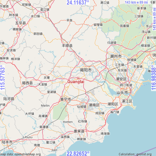
Guangtai GPS coordinates[2]
23° 28' 22.872" North, 116° 16' 50.7" East
| Map corner | latitude | longitude |
|---|---|---|
| Upper-left | 24.11637°, | 115.57763° |
| Center: | 23.47302°, | 116.28075° |
| Lower-right: | 22.82652°, | 116.98388° |
| Map W x H: | 143.4×143.4 km | = 89.1×89.1mi |
| max Lat: | 53.31946° ⇑92.3% North |
| Guangtai: | 23.47302° |
| min Lat: | ⇓7.7% South 18.22056° |
| min Long | Guangtai | max Long |
| 75.07348° | 116.28075° | 134.28917° |
| W 61.7%⇐ | ⇒38.3% E |
Elevation
Elevation of Guangtai is 125 m = 410 ft, and this is 359.8 m = 1180 ft below average elevation for this country.
| Max E: |
5622 m = 18445 ft | 55.9% |
| Avg. | 484.8 m = 1591 ft | |
| Guangtai | 125 m = 410 ft | |
Min E: |
-3 m = -10 ft | 44.1% |
See also: China elevation on elevation.city.
Geographical zone
Guangtai is located in North temperate zone (between Tropic of Cancer and the Arctic Circle). Distance of this Northern Tropic circle is 4 km =2.5 mi to South.| Distance of | km | miles | from Guangtai |
|---|---|---|---|
| North Pole | 7397.1 | 4596.3 | to North |
| Arctic Circle | 4791.2 | 2977.1 | to North |
| Tropic Cancer | 4 | 2.5 | to South |
| Equator | 2610 | 1621.8 | to South |


Nearby cities:
15 places around Guangtai: (largest is in red/bold)
• Baita
12.6 km =7.8 mi,  320°
320°
• Chigang
12.2 km =7.6 mi,  249°
249°
• Daba
15.4 km =9.6 mi,  218°
218°
• Guiling
13.5 km =8.4 mi,  340°
340°
• Hongyang
8.3 km =5.2 mi,  235°
235°
• Jieyang
11.6 km =7.2 mi,  48°
48°
• Jinzao
11.4 km =7.1 mi,  100°
100°
• Linpan
10.1 km =6.3 mi,  333°
333°
• Meiyun
6.2 km =3.9 mi,  31°
31°
• Mianhu
14.9 km =9.3 mi,  256°
256°
• Nanjing
14.9 km =9.3 mi,  173°
173°
• Nanxi
5.6 km =3.5 mi,  311°
311°
• Qilin
5.6 km =3.5 mi,  175°
175°
• Xianqiao
7.3 km =4.5 mi,  68°
68°
• Yuecheng
10.1 km =6.3 mi,  353°
353°
Sources, notices
• [Note1] Compared only with cities in China existing in our database
• [Src1] Map data: © OpenStreetMap contributors (CC-BY-SA)
• [Src2] Other city data from geonames.org with taken over terms of usage.
• [Src3] Geographical zone / Annual Mean Temperature by Robert A. Rohde @ Wikipedia
