Hefeng geodata
Hefeng (Jiangsu) is a seat of a fourth-order administrative division; located in China in Asia/Shanghai (GMT+8) time zone. In our database, there are 1268 cities with bigger population. Compared to other cities in China, 57.7% of cities are located further ↓South; 76% of cities are located further ←West and 86.9% of cities have higher elevation than Hefeng. Note1


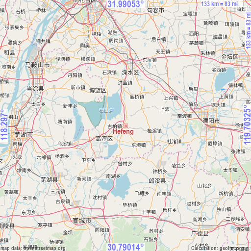
Hefeng GPS coordinates[2]
31° 23' 32.1" North, 119° 0' 0.432" East
| Map corner | latitude | longitude |
|---|---|---|
| Upper-left | 31.99053°, | 118.297° |
| Center: | 31.39225°, | 119.00012° |
| Lower-right: | 30.79014°, | 119.70325° |
| Map W x H: | 133.5×133.5 km | = 83×83mi |
| max Lat: | 53.31946° ⇑42.3% North |
| Hefeng: | 31.39225° |
| min Lat: | ⇓57.7% South 18.22056° |
| min Long | Hefeng | max Long |
| 75.07348° | 119.00012° | 134.28917° |
| W 76%⇐ | ⇒24% E |
Elevation
Elevation of Hefeng is 13 m = 43 ft, and this is 471.8 m = 1548 ft below average elevation for this country.
| Max E: |
5622 m = 18445 ft | 86.9% |
| Avg. | 484.8 m = 1591 ft | |
| Hefeng | 13 m = 43 ft | |
Min E: |
-3 m = -10 ft | 13.1% |
See also: China elevation on elevation.city.
Geographical zone
Hefeng is located in North temperate zone (between Tropic of Cancer and the Arctic Circle). Distance of this Northern Tropic circle is 884.6 km =549.7 mi to South.| Distance of | km | miles | from Hefeng |
|---|---|---|---|
| North Pole | 6516.6 | 4049.2 | to North |
| Arctic Circle | 3910.7 | 2430 | to North |
| Tropic Cancer | 884.6 | 549.7 | to South |
| Equator | 3490.5 | 2168.9 | to South |


Nearby cities:
15 places around Hefeng: (largest is in red/bold)
• Changqiao
17.9 km =11.1 mi,  24°
24°
• Chunxi
13.9 km =8.6 mi,  238°
238°
• Dingbu
18.8 km =11.7 mi,  125°
125°
• Dongba
11.7 km =7.3 mi,  154°
154°
• Gucheng
10.2 km =6.3 mi,  198°
198°
• Honglan
24 km =14.9 mi,  355°
355°
• Huyang
16.9 km =10.5 mi,  267°
267°
• Jingqiao
16.8 km =10.4 mi, 20°
• Liqiao
20.8 km =12.9 mi, 201°
• Qiqiao
1.3 km =0.8 mi,  248°
248°
• Shangpei
22.6 km =14 mi,  66°
66°
• Xinfa
23.2 km =14.4 mi, 154°
• Yangjiang
19.4 km =12.1 mi, 250°
• Yaxi
15.4 km =9.6 mi,  99°
99°
• Zhuanqiang
22.5 km =14 mi,  230°
230°
Sources, notices
• [Note1] Compared only with cities in China existing in our database
• [Src1] Map data: © OpenStreetMap contributors (CC-BY-SA)
• [Src2] Other city data from geonames.org with taken over terms of usage.
• [Src3] Geographical zone / Annual Mean Temperature by Robert A. Rohde @ Wikipedia
