Yangjiang geodata
Yangjiang (Jiangsu) is a seat of a fourth-order administrative division; located in China in Asia/Shanghai (GMT+8) time zone. In our database, there are 1268 cities with bigger population. Compared to other cities in China, 57.3% of cities are located further ↓South; 75.1% of cities are located further ←West and 88.7% of cities have higher elevation than Yangjiang. Note1


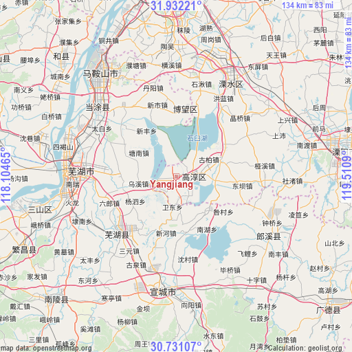
Yangjiang GPS coordinates[2]
31° 20' 0.816" North, 118° 48' 27.972" East
| Map corner | latitude | longitude |
|---|---|---|
| Upper-left | 31.93221°, | 118.10465° |
| Center: | 31.33356°, | 118.80777° |
| Lower-right: | 30.73107°, | 119.5109° |
| Map W x H: | 133.6×133.6 km | = 83×83mi |
| max Lat: | 53.31946° ⇑42.7% North |
| Yangjiang: | 31.33356° |
| min Lat: | ⇓57.3% South 18.22056° |
| min Long | Yangjiang | max Long |
| 75.07348° | 118.80777° | 134.28917° |
| W 75.1%⇐ | ⇒24.9% E |
Elevation
Elevation of Yangjiang is 11 m = 36 ft, and this is 473.8 m = 1554 ft below average elevation for this country.
| Max E: |
5622 m = 18445 ft | 88.7% |
| Avg. | 484.8 m = 1591 ft | |
| Yangjiang | 11 m = 36 ft | |
Min E: |
-3 m = -10 ft | 11.3% |
See also: China elevation on elevation.city.
Geographical zone
Yangjiang is located in North temperate zone (between Tropic of Cancer and the Arctic Circle). Distance of this Northern Tropic circle is 878 km =545.6 mi to South.| Distance of | km | miles | from Yangjiang |
|---|---|---|---|
| North Pole | 6523.1 | 4053.3 | to North |
| Arctic Circle | 3917.2 | 2434 | to North |
| Tropic Cancer | 878 | 545.6 | to South |
| Equator | 3484 | 2164.9 | to South |


Nearby cities:
15 places around Yangjiang: (largest is in red/bold)
• Chunxi
6.4 km =4 mi,  95°
95°
• Dalong
14.3 km =8.9 mi,  321°
321°
• Gucheng
15.4 km =9.6 mi, 101°
• Hefeng
19.4 km =12.1 mi,  70°
70°
• Huangchi
20 km =12.4 mi,  259°
259°
• Huaqiao
19.6 km =12.2 mi,  213°
213°
• Huyang
6 km =3.7 mi,  13°
13°
• Liqiao
16.8 km =10.4 mi,  140°
140°
• Maqiao
21.1 km =13.1 mi,  293°
293°
• Qiqiao
18.1 km =11.2 mi, 70°
• Shuiyang
11.7 km =7.3 mi,  188°
188°
• Tangnan
16.8 km =10.4 mi,  302°
302°
• Wuxi
14.6 km =9.1 mi, 259°
• Xinfeng
20.7 km =12.9 mi,  326°
326°
• Zhuanqiang
7.9 km =4.9 mi,  173°
173°
Sources, notices
• [Note1] Compared only with cities in China existing in our database
• [Src1] Map data: © OpenStreetMap contributors (CC-BY-SA)
• [Src2] Other city data from geonames.org with taken over terms of usage.
• [Src3] Geographical zone / Annual Mean Temperature by Robert A. Rohde @ Wikipedia
