Liujia geodata
Liujia (Yunnan) is a seat of a fourth-order administrative division; located in China in Asia/Shanghai (GMT+8) time zone. In our database, there are 1268 cities with bigger population. Compared to other cities in China, 86.5% of cities are located further ↑North; 92% of cities are located further →East and 94.1% of cities have lower elevation than Liujia. Note1


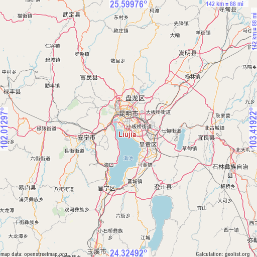
Liujia GPS coordinates[2]
24° 57' 50.364" North, 102° 42' 57.924" East
| Map corner | latitude | longitude |
|---|---|---|
| Upper-left | 25.59976°, | 102.01297° |
| Center: | 24.96399°, | 102.71609° |
| Lower-right: | 24.32492°, | 103.41922° |
| Map W x H: | 141.7×141.8 km | = 88×88.1mi |
| max Lat: | 53.31946° ⇑86.5% North |
| Liujia: | 24.96399° |
| min Lat: | ⇓13.5% South 18.22056° |
| min Long | Liujia | max Long |
| 75.07348° | 102.71609° | 134.28917° |
| W 8%⇐ | ⇒92% E |
Elevation
Elevation of Liujia is 1887 m = 6191 ft, and this is 1402.2 m = 4600 ft above average elevation for this country.
| Max E: |
5622 m = 18445 ft | 5.9% |
| Liujia | 1887 m 6191 ft | |
| Avg. | 484.8 m = 1591 ft | |
Min E: |
-3 m = -10 ft | 94.1% |
See also: China elevation on elevation.city.
Geographical zone
Liujia is located in North temperate zone (between Tropic of Cancer and the Arctic Circle). Distance of this Northern Tropic circle is 169.8 km =105.5 mi to South.| Distance of | km | miles | from Liujia |
|---|---|---|---|
| North Pole | 7231.3 | 4493.3 | to North |
| Arctic Circle | 4625.4 | 2874.1 | to North |
| Tropic Cancer | 169.8 | 105.5 | to South |
| Equator | 2775.7 | 1724.7 | to South |


Nearby cities:
15 places around Liujia: (largest is in red/bold)
• Ala
8.2 km =5.1 mi,  62°
62°
• Gaoyao
9.7 km =6 mi,  284°
284°
• Geyang
9.5 km =5.9 mi,  112°
112°
• Huacheng
21.5 km =13.4 mi,  155°
155°
• Kunming
8.3 km =5.2 mi,  1°
1°
• Lianran
23.7 km =14.7 mi,  258°
258°
• Longcheng
11.2 km =7 mi,  130°
130°
• Luoyang
9.8 km =6.1 mi, 112°
• Majie
10.9 km =6.8 mi,  313°
313°
• Qidian
23.3 km =14.5 mi,  90°
90°
• Taiping
12.9 km =8 mi, 264°
• Taipingguan
16.7 km =10.4 mi,  153°
153°
• Wujiaying
16.4 km =10.2 mi, 127°
• Xiaobanqiao
6.1 km =3.8 mi,  73°
73°
• Xiaowangjiaying
9.5 km =5.9 mi, 126°
Sources, notices
• [Note1] Compared only with cities in China existing in our database
• [Src1] Map data: © OpenStreetMap contributors (CC-BY-SA)
• [Src2] Other city data from geonames.org with taken over terms of usage.
• [Src3] Geographical zone / Annual Mean Temperature by Robert A. Rohde @ Wikipedia
