Dayingjie geodata
Dayingjie (Yunnan) is a seat of a fourth-order administrative division; located in China in Asia/Shanghai (GMT+8) time zone. In our database, there are 1268 cities with bigger population. Compared to other cities in China, 89.1% of cities are located further ↑North; 92.3% of cities are located further →East and 92.4% of cities have lower elevation than Dayingjie. Note1


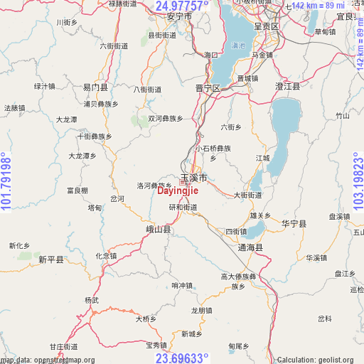
Dayingjie GPS coordinates[2]
24° 20' 18.852" North, 102° 29' 42.36" East
| Map corner | latitude | longitude |
|---|---|---|
| Upper-left | 24.97757°, | 101.79198° |
| Center: | 24.33857°, | 102.4951° |
| Lower-right: | 23.69633°, | 103.19823° |
| Map W x H: | 142.5×142.5 km | = 88.5×88.5mi |
| max Lat: | 53.31946° ⇑89.1% North |
| Dayingjie: | 24.33857° |
| min Lat: | ⇓10.9% South 18.22056° |
| min Long | Dayingjie | max Long |
| 75.07348° | 102.4951° | 134.28917° |
| W 7.7%⇐ | ⇒92.3% E |
Elevation
Elevation of Dayingjie is 1623 m = 5325 ft, and this is 1138.2 m = 3734 ft above average elevation for this country.
| Max E: |
5622 m = 18445 ft | 7.6% |
| Dayingjie | 1623 m 5325 ft | |
| Avg. | 484.8 m = 1591 ft | |
Min E: |
-3 m = -10 ft | 92.4% |
See also: China elevation on elevation.city.
Geographical zone
Dayingjie is located in North temperate zone (between Tropic of Cancer and the Arctic Circle). Distance of this Northern Tropic circle is 100.3 km =62.3 mi to South.| Distance of | km | miles | from Dayingjie |
|---|---|---|---|
| North Pole | 7300.9 | 4536.6 | to North |
| Arctic Circle | 4695 | 2917.3 | to North |
| Tropic Cancer | 100.3 | 62.3 | to South |
| Equator | 2706.2 | 1681.6 | to South |


Nearby cities:
15 places around Dayingjie: (largest is in red/bold)
• Anhua Daying
20.1 km =12.5 mi,  63°
63°
• Beicheng
11.2 km =7 mi,  28°
28°
• Chunhe
8 km =5 mi, 26°
• Dayingjie
15 km =9.3 mi,  103°
103°
• Gaocang
3.3 km =2.1 mi,  124°
124°
• Liqi
8 km =5 mi,  46°
46°
• Luohe
10.8 km =6.7 mi,  265°
265°
• Qianwei
23.7 km =14.7 mi,  89°
89°
• Shangfang Xinjie
24.7 km =15.3 mi,  13°
13°
• Shuangjiang
20.8 km =12.9 mi,  207°
207°
• Xiaojie
20.4 km =12.7 mi,  189°
189°
• Xiaoshiqiao
17.3 km =10.7 mi, 45°
• Xiyang
25 km =15.5 mi,  303°
303°
• Yanhe
8.9 km =5.5 mi,  179°
179°
• Yuxi
5.1 km =3.2 mi,  69°
69°
Sources, notices
• [Note1] Compared only with cities in China existing in our database
• [Src1] Map data: © OpenStreetMap contributors (CC-BY-SA)
• [Src2] Other city data from geonames.org with taken over terms of usage.
• [Src3] Geographical zone / Annual Mean Temperature by Robert A. Rohde @ Wikipedia
