Fucheng geodata
Fucheng (Guangdong) is a seat of a fourth-order administrative division; located in China in Asia/Urumqi (GMT+6) time zone. In our database, there are 1268 cities with bigger population. Compared to other cities in China, 98.5% of cities are located further ↑North; 70.8% of cities are located further →East and 83.9% of cities have higher elevation than Fucheng. Note1


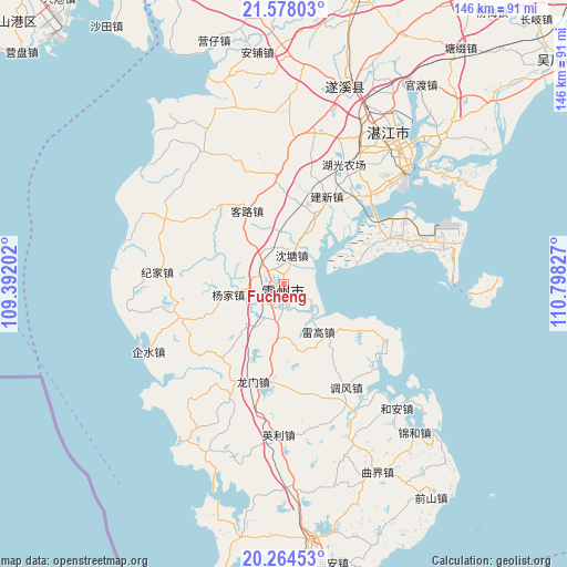
Fucheng GPS coordinates[2]
20° 55' 21.792" North, 110° 5' 42.504" East
| Map corner | latitude | longitude |
|---|---|---|
| Upper-left | 21.57803°, | 109.39202° |
| Center: | 20.92272°, | 110.09514° |
| Lower-right: | 20.26453°, | 110.79827° |
| Map W x H: | 146×146 km | = 90.7×90.7mi |
| max Lat: | 53.31946° ⇑98.5% North |
| Fucheng: | 20.92272° |
| min Lat: | ⇓1.5% South 18.22056° |
| min Long | Fucheng | max Long |
| 75.07348° | 110.09514° | 134.28917° |
| W 29.2%⇐ | ⇒70.8% E |
Elevation
Elevation of Fucheng is 18 m = 59 ft, and this is 466.8 m = 1531 ft below average elevation for this country.
| Max E: |
5622 m = 18445 ft | 83.9% |
| Avg. | 484.8 m = 1591 ft | |
| Fucheng | 18 m = 59 ft | |
Min E: |
-3 m = -10 ft | 16.1% |
See also: China elevation on elevation.city.
Geographical zone
Fucheng is located in North Torrid zone (between Equator and Tropic of Cancer). Distance of this Northern Tropic circle is 279.5 km =173.7 mi to North.| Distance of | km | miles | from Fucheng |
|---|---|---|---|
| North Pole | 7680.7 | 4772.6 | to North |
| Arctic Circle | 5074.8 | 3153.3 | to North |
| Tropic Cancer | 279.5 | 173.7 | to North |
| Equator | 2326.4 | 1445.6 | to South |


Nearby cities:
15 places around Fucheng: (largest is in red/bold)
• Baisha
3.6 km =2.2 mi,  190°
190°
• Chengyue
27.2 km =16.9 mi,  354°
354°
• Hetou
29.5 km =18.3 mi,  300°
300°
• Jianxin
24.2 km =15 mi,  27°
27°
• Kelu
20 km =12.4 mi,  336°
336°
• Leicheng
1.4 km =0.9 mi,  236°
236°
• Leigao
16.2 km =10.1 mi,  140°
140°
• Longmen
24.3 km =15.1 mi, 194°
• Min’an
25.4 km =15.8 mi,  66°
66°
• Nanxing
13.2 km =8.2 mi,  180°
180°
• Shentang
9 km =5.6 mi,  17°
17°
• Songzhu
8.4 km =5.2 mi,  207°
207°
• Taiping
14.9 km =9.3 mi, 25°
• Tangjia
27.3 km =17 mi,  250°
250°
• Yangjia
14.3 km =8.9 mi,  258°
258°
Sources, notices
• [Note1] Compared only with cities in China existing in our database
• [Src1] Map data: © OpenStreetMap contributors (CC-BY-SA)
• [Src2] Other city data from geonames.org with taken over terms of usage.
• [Src3] Geographical zone / Annual Mean Temperature by Robert A. Rohde @ Wikipedia
