Min’an geodata
Min’an (Guangdong) is a seat of a fourth-order administrative division; located in China in Asia/Urumqi (GMT+6) time zone. In our database, there are 1268 cities with bigger population. Compared to other cities in China, 98.5% of cities are located further ↑North; 69.9% of cities are located further →East and 84.3% of cities have higher elevation than Min’an. Note1


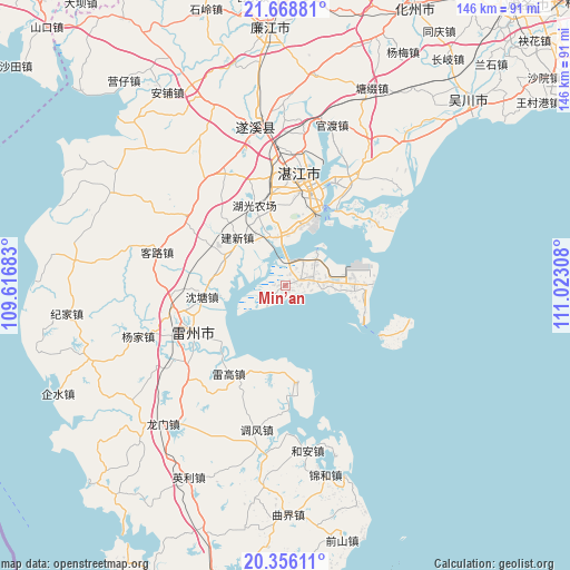
Min’an GPS coordinates[2]
21° 0' 50.04" North, 110° 19' 11.82" East
| Map corner | latitude | longitude |
|---|---|---|
| Upper-left | 21.66881°, | 109.61683° |
| Center: | 21.0139°, | 110.31995° |
| Lower-right: | 20.35611°, | 111.02308° |
| Map W x H: | 146×146 km | = 90.7×90.7mi |
| max Lat: | 53.31946° ⇑98.5% North |
| Min’an: | 21.0139° |
| min Lat: | ⇓1.5% South 18.22056° |
| min Long | Min’an | max Long |
| 75.07348° | 110.31995° | 134.28917° |
| W 30.1%⇐ | ⇒69.9% E |
Elevation
Elevation of Min’an is 17 m = 56 ft, and this is 467.8 m = 1535 ft below average elevation for this country.
| Max E: |
5622 m = 18445 ft | 84.3% |
| Avg. | 484.8 m = 1591 ft | |
| Min’an | 17 m = 56 ft | |
Min E: |
-3 m = -10 ft | 15.7% |
See also: China elevation on elevation.city.
Geographical zone
Min’an is located in North Torrid zone (between Equator and Tropic of Cancer). Distance of this Northern Tropic circle is 269.4 km =167.4 mi to North.| Distance of | km | miles | from Min’an |
|---|---|---|---|
| North Pole | 7670.5 | 4766.2 | to North |
| Arctic Circle | 5064.6 | 3147 | to North |
| Tropic Cancer | 269.4 | 167.4 | to North |
| Equator | 2336.5 | 1451.8 | to South |


Nearby cities:
15 places around Min’an: (largest is in red/bold)
• Baisha
27.6 km =17.1 mi,  240°
240°
• Dongjian
18.4 km =11.4 mi,  82°
82°
• Dongli
25 km =15.5 mi,  170°
170°
• Dongshan
7.9 km =4.9 mi,  72°
72°
• Fucheng
25.4 km =15.8 mi,  246°
246°
• Gongnong
21.4 km =13.3 mi,  21°
21°
• Haitou
21.9 km =13.6 mi, 18°
• Huguang
12.9 km =8 mi,  345°
345°
• Jianxin
16.7 km =10.4 mi,  312°
312°
• Leicheng
26.9 km =16.7 mi, 245°
• Leigao
26.3 km =16.3 mi,  209°
209°
• Nanqiao
28.5 km =17.7 mi,  8°
8°
• Nansan
28.4 km =17.6 mi,  57°
57°
• Shentang
20.7 km =12.9 mi,  265°
265°
• Taiping
17.2 km =10.7 mi,  281°
281°
Sources, notices
• [Note1] Compared only with cities in China existing in our database
• [Src1] Map data: © OpenStreetMap contributors (CC-BY-SA)
• [Src2] Other city data from geonames.org with taken over terms of usage.
• [Src3] Geographical zone / Annual Mean Temperature by Robert A. Rohde @ Wikipedia
