Songzhu geodata
Songzhu (Guangdong) is a seat of a fourth-order administrative division; located in China in Asia/Urumqi (GMT+6) time zone. In our database, there are 1268 cities with bigger population. Compared to other cities in China, 98.5% of cities are located further ↑North; 71% of cities are located further →East and 99.7% of cities have higher elevation than Songzhu. Note1


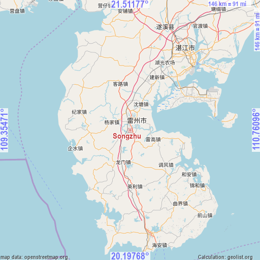
Songzhu GPS coordinates[2]
20° 51' 22.176" North, 110° 3' 28.188" East
| Map corner | latitude | longitude |
|---|---|---|
| Upper-left | 21.51177°, | 109.35471° |
| Center: | 20.85616°, | 110.05783° |
| Lower-right: | 20.19768°, | 110.76096° |
| Map W x H: | 146.1×146.1 km | = 90.8×90.8mi |
| max Lat: | 53.31946° ⇑98.5% North |
| Songzhu: | 20.85616° |
| min Lat: | ⇓1.5% South 18.22056° |
| min Long | Songzhu | max Long |
| 75.07348° | 110.05783° | 134.28917° |
| W 29%⇐ | ⇒71% E |
Elevation
Elevation of Songzhu is 1 m = 3 ft, and this is 483.8 m = 1587 ft below average elevation for this country.
| Max E: |
5622 m = 18445 ft | 99.7% |
| Avg. | 484.8 m = 1591 ft | |
| Songzhu | 1 m = 3 ft | |
Min E: |
-3 m = -10 ft | 0.3% |
See also: China elevation on elevation.city.
Geographical zone
Songzhu is located in North Torrid zone (between Equator and Tropic of Cancer). Distance of this Northern Tropic circle is 286.9 km =178.3 mi to North.| Distance of | km | miles | from Songzhu |
|---|---|---|---|
| North Pole | 7688.1 | 4777.2 | to North |
| Arctic Circle | 5082.2 | 3157.9 | to North |
| Tropic Cancer | 286.9 | 178.3 | to North |
| Equator | 2319 | 1441 | to South |


Nearby cities:
15 places around Songzhu: (largest is in red/bold)
• Baisha
5 km =3.1 mi,  39°
39°
• Beihe
29.4 km =18.3 mi,  219°
219°
• Fucheng
8.4 km =5.2 mi,  27°
27°
• Hetou
31.1 km =19.3 mi,  316°
316°
• Jijia
29.4 km =18.3 mi,  291°
291°
• Kelu
26 km =16.2 mi,  350°
350°
• Leicheng
7.1 km =4.4 mi,  22°
22°
• Leigao
15 km =9.3 mi,  110°
110°
• Longmen
16.3 km =10.1 mi,  187°
187°
• Nanxing
6.9 km =4.3 mi,  147°
147°
• Shentang
17.3 km =10.7 mi, 22°
• Taiping
23.3 km =14.5 mi, 26°
• Tangjia
22 km =13.7 mi,  266°
266°
• Tiaofeng
27.6 km =17.1 mi,  133°
133°
• Yangjia
11.1 km =6.9 mi, 294°
Sources, notices
• [Note1] Compared only with cities in China existing in our database
• [Src1] Map data: © OpenStreetMap contributors (CC-BY-SA)
• [Src2] Other city data from geonames.org with taken over terms of usage.
• [Src3] Geographical zone / Annual Mean Temperature by Robert A. Rohde @ Wikipedia
